Wyanet geodata
Wyanet (Illinois) is a populated place; located in United States in America/Chicago (GMT-5) time zone. With population of 956 people, there are 16596 cities with bigger population in this country. Compared to other cities in United States, 69.5% of cities are located further ↓South; 57.8% of cities are located further →East and 51.9% of cities have lower elevation than Wyanet. Note1


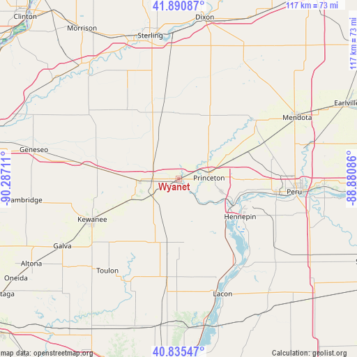
Wyanet GPS coordinates[2]
41° 21' 55.116" North, 89° 35' 2.328" West
| Map corner | latitude | longitude |
|---|---|---|
| Upper-left | 41.89087°, | -90.28711° |
| Center: | 41.36531°, | -89.58398° |
| Lower-right: | 40.83547°, | -88.88086° |
| Map W x H: | 117.3×117.3 km | = 72.9×72.9mi |
| max Lat: | 71.29058° ⇑30.5% North |
| Wyanet: | 41.36531° |
| min Lat: | ⇓69.5% South 19.06759° |
| min Long | Wyanet | max Long |
| -171.73463° | -89.58398° | -66.98998° |
| W 42.2%⇐ | ⇒57.8% E |
Elevation
Elevation of Wyanet is 206 m = 676 ft, and this is 88.8 m = 291 ft below average elevation for this country.
| Max E: |
3189 m = 10463 ft | 48.1% |
| Avg. | 294.8 m = 967 ft | |
| Wyanet | 206 m = 676 ft | |
Min E: |
-60 m = -197 ft | 51.9% |
See also: United States elevation on elevation.city.
Geographical zone
Wyanet is located in North temperate zone (between Tropic of Cancer and the Arctic Circle). Distance of this Northern Tropic circle is 1993.5 km =1238.7 mi to South.| Distance of | km | miles | from Wyanet |
|---|---|---|---|
| North Pole | 5407.7 | 3360.2 | to North |
| Arctic Circle | 2801.8 | 1741 | to North |
| Tropic Cancer | 1993.5 | 1238.7 | to South |
| Equator | 4599.4 | 2857.9 | to South |


Nearby cities:
15 places around Wyanet: (largest is in red/bold)
• Annawan
27 km =16.8 mi,  277°
277°
• Bradford
21.8 km =13.5 mi,  196°
196°
• Buda
9 km =5.6 mi,  241°
241°
• Depue
23.6 km =14.7 mi,  101°
101°
• Granville
31.9 km =19.8 mi,  111°
111°
• Hennepin
23.7 km =14.7 mi,  121°
121°
• Kewanee
31.4 km =19.5 mi, 244°
• La Moille
31.4 km =19.5 mi,  53°
53°
• Ladd
30.5 km =19 mi,  86°
86°
• Mark
30.1 km =18.7 mi, 111°
• Princeton
9.9 km =6.2 mi, 88°
• Sheffield
12.8 km =8 mi,  266°
266°
• Spring Valley
32.3 km =20.1 mi, 97°
• Tiskilwa
10.4 km =6.5 mi,  141°
141°
• Walnut
21.3 km =13.2 mi,  357°
357°
Sources, notices
• [Note1] Compared only with cities in United States existing in our database
• [Src1] Map data: © OpenStreetMap contributors (CC-BY-SA)
• [Src2] Other city data from geonames.org with taken over terms of usage.
• [Src3] Geographical zone / Annual Mean Temperature by Robert A. Rohde @ Wikipedia
