Kewanee geodata
Kewanee (Illinois) is a populated place; located in United States in America/Chicago (GMT-5) time zone. With population of 12,533 people, there are 3771 cities with bigger population in this country. Compared to other cities in United States, 68.2% of cities are located further ↓South; 58.8% of cities are located further →East and 64.5% of cities have lower elevation than Kewanee. Note1


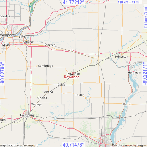
Kewanee GPS coordinates[2]
41° 14' 44.124" North, 89° 55' 29.388" West
| Map corner | latitude | longitude |
|---|---|---|
| Upper-left | 41.77212°, | -90.62796° |
| Center: | 41.24559°, | -89.92483° |
| Lower-right: | 40.71478°, | -89.22171° |
| Map W x H: | 117.6×117.6 km | = 73.1×73.1mi |
| max Lat: | 71.29058° ⇑31.8% North |
| Kewanee: | 41.24559° |
| min Lat: | ⇓68.2% South 19.06759° |
| min Long | Kewanee | max Long |
| -171.73463° | -89.92483° | -66.98998° |
| W 41.2%⇐ | ⇒58.8% E |
Elevation
Elevation of Kewanee is 260 m = 853 ft, and this is 34.8 m = 114 ft below average elevation for this country.
| Max E: |
3189 m = 10463 ft | 35.5% |
| Avg. | 294.8 m = 967 ft | |
| Kewanee | 260 m = 853 ft | |
Min E: |
-60 m = -197 ft | 64.5% |
See also: United States elevation on elevation.city.
Geographical zone
Kewanee is located in North temperate zone (between Tropic of Cancer and the Arctic Circle). Distance of this Northern Tropic circle is 1980.2 km =1230.4 mi to South.| Distance of | km | miles | from Kewanee |
|---|---|---|---|
| North Pole | 5421 | 3368.5 | to North |
| Arctic Circle | 2815.1 | 1749.2 | to North |
| Tropic Cancer | 1980.2 | 1230.4 | to South |
| Equator | 4586.1 | 2849.7 | to South |


Nearby cities:
15 places around Kewanee: (largest is in red/bold)
• Altona
24.8 km =15.4 mi,  234°
234°
• Andover
31.2 km =19.4 mi,  279°
279°
• Annawan
16.9 km =10.5 mi,  5°
5°
• Atkinson
20.9 km =13 mi,  338°
338°
• Bradford
23.6 km =14.7 mi,  108°
108°
• Buda
22.4 km =13.9 mi,  66°
66°
• Cambridge
23.3 km =14.5 mi,  286°
286°
• Galva
13.1 km =8.1 mi, 228°
• Geneseo
29.6 km =18.4 mi,  319°
319°
• Oneida
31.7 km =19.7 mi, 232°
• Sheffield
20.1 km =12.5 mi,  51°
51°
• Toulon
17.6 km =10.9 mi,  163°
163°
• Woodhull
33.5 km =20.8 mi,  257°
257°
• Wyanet
31.4 km =19.5 mi,  64°
64°
• Wyoming
24.1 km =15 mi,  148°
148°
Sources, notices
• [Note1] Compared only with cities in United States existing in our database
• [Src1] Map data: © OpenStreetMap contributors (CC-BY-SA)
• [Src2] Other city data from geonames.org with taken over terms of usage.
• [Src3] Geographical zone / Annual Mean Temperature by Robert A. Rohde @ Wikipedia
