Hammond geodata
Hammond (Indiana) is a populated place; located in United States in America/Chicago (GMT-5) time zone. With population of 77,614 people, there are 515 cities with bigger population in this country. Compared to other cities in United States, 71.7% of cities are located further ↓South; 50.8% of cities are located further →East and 52.8% of cities have higher elevation than Hammond. Note1


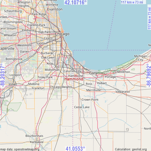
Hammond GPS coordinates[2]
41° 35' 0.132" North, 87° 30' 0.144" West
| Map corner | latitude | longitude |
|---|---|---|
| Upper-left | 42.10716°, | -88.20317° |
| Center: | 41.58337°, | -87.50004° |
| Lower-right: | 41.0553°, | -86.79692° |
| Map W x H: | 117×117 km | = 72.7×72.7mi |
| max Lat: | 71.29058° ⇑28.3% North |
| Hammond: | 41.58337° |
| min Lat: | ⇓71.7% South 19.06759° |
| min Long | Hammond | max Long |
| -171.73463° | -87.50004° | -66.98998° |
| W 49.2%⇐ | ⇒50.8% E |
Elevation
Elevation of Hammond is 188 m = 617 ft, and this is 106.8 m = 350 ft below average elevation for this country.
| Max E: |
3189 m = 10463 ft | 52.8% |
| Avg. | 294.8 m = 967 ft | |
| Hammond | 188 m = 617 ft | |
Min E: |
-60 m = -197 ft | 47.2% |
See also: Hammond elevation on elevation.city.
Geographical zone
Hammond is located in North temperate zone (between Tropic of Cancer and the Arctic Circle). Distance of this Northern Tropic circle is 2017.7 km =1253.7 mi to South.| Distance of | km | miles | from Hammond |
|---|---|---|---|
| North Pole | 5383.4 | 3345.1 | to North |
| Arctic Circle | 2777.5 | 1725.9 | to North |
| Tropic Cancer | 2017.7 | 1253.7 | to South |
| Equator | 4623.6 | 2873 | to South |


Nearby cities:
15 places around Hammond: (largest is in red/bold)
• Burnham
7.8 km =4.8 mi,  322°
322°
• Calumet City
4.3 km =2.7 mi,  325°
325°
• Dolton
10.8 km =6.7 mi,  304°
304°
• Dyer
10.1 km =6.3 mi,  190°
190°
• East Chicago
7.3 km =4.5 mi,  31°
31°
• Ford Heights
11.5 km =7.1 mi,  221°
221°
• Glenwood
9.6 km =6 mi,  241°
241°
• Griffith
8.8 km =5.5 mi,  133°
133°
• Highland
5.2 km =3.2 mi, 129°
• Lansing
3.8 km =2.4 mi, 237°
• Lynwood
7.1 km =4.4 mi,  206°
206°
• Munster
2.3 km =1.4 mi, 206°
• South Holland
9.1 km =5.7 mi,  282°
282°
• Thornton
9.1 km =5.7 mi,  259°
259°
• Whiting
10.7 km =6.6 mi,  2°
2°
Sources, notices
• [Note1] Compared only with cities in United States existing in our database
• [Src1] Map data: © OpenStreetMap contributors (CC-BY-SA)
• [Src2] Other city data from geonames.org with taken over terms of usage.
• [Src3] Geographical zone / Annual Mean Temperature by Robert A. Rohde @ Wikipedia
