Griffith geodata
Griffith (Indiana) is a populated place; located in United States in America/Chicago (GMT-5) time zone. With population of 16,378 people, there are 3001 cities with bigger population in this country. Compared to other cities in United States, 71.2% of cities are located further ↓South; 50.6% of cities are located further →East and 50.3% of cities have higher elevation than Griffith. Note1


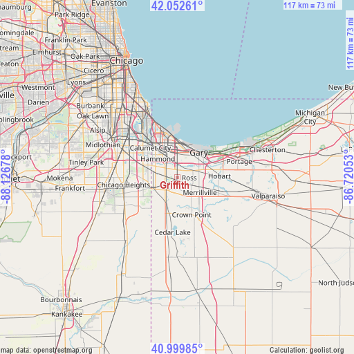
Griffith GPS coordinates[2]
41° 31' 42.132" North, 87° 25' 25.14" West
| Map corner | latitude | longitude |
|---|---|---|
| Upper-left | 42.05261°, | -88.12678° |
| Center: | 41.52837°, | -87.42365° |
| Lower-right: | 40.99985°, | -86.72053° |
| Map W x H: | 117.1×117.1 km | = 72.8×72.8mi |
| max Lat: | 71.29058° ⇑28.8% North |
| Griffith: | 41.52837° |
| min Lat: | ⇓71.2% South 19.06759° |
| min Long | Griffith | max Long |
| -171.73463° | -87.42365° | -66.98998° |
| W 49.4%⇐ | ⇒50.6% E |
Elevation
Elevation of Griffith is 197 m = 646 ft, and this is 97.8 m = 321 ft below average elevation for this country.
| Max E: |
3189 m = 10463 ft | 50.3% |
| Avg. | 294.8 m = 967 ft | |
| Griffith | 197 m = 646 ft | |
Min E: |
-60 m = -197 ft | 49.7% |
See also: United States elevation on elevation.city.
Geographical zone
Griffith is located in North temperate zone (between Tropic of Cancer and the Arctic Circle). Distance of this Northern Tropic circle is 2011.6 km =1249.9 mi to South.| Distance of | km | miles | from Griffith |
|---|---|---|---|
| North Pole | 5389.5 | 3348.9 | to North |
| Arctic Circle | 2783.7 | 1729.7 | to North |
| Tropic Cancer | 2011.6 | 1249.9 | to South |
| Equator | 4617.5 | 2869.2 | to South |


Nearby cities:
15 places around Griffith: (largest is in red/bold)
• Calumet City
13.1 km =8.1 mi,  317°
317°
• Dyer
9 km =5.6 mi,  245°
245°
• East Chicago
12.6 km =7.8 mi,  348°
348°
• Gary
9.7 km =6 mi,  41°
41°
• Hammond
8.8 km =5.5 mi,  313°
313°
• Highland
3.7 km =2.3 mi, 320°
• Lansing
10.4 km =6.5 mi,  292°
292°
• Lynwood
9.6 km =6 mi,  268°
268°
• Merrillville
9.1 km =5.7 mi,  123°
123°
• Munster
8.4 km =5.2 mi,  298°
298°
• New Chicago
12.9 km =8 mi,  74°
74°
• Saint John
9.5 km =5.9 mi,  203°
203°
• Sauk Village
12.8 km =8 mi, 249°
• Schererville
6.1 km =3.8 mi,  205°
205°
• Willowbrook
12.2 km =7.6 mi,  230°
230°
Sources, notices
• [Note1] Compared only with cities in United States existing in our database
• [Src1] Map data: © OpenStreetMap contributors (CC-BY-SA)
• [Src2] Other city data from geonames.org with taken over terms of usage.
• [Src3] Geographical zone / Annual Mean Temperature by Robert A. Rohde @ Wikipedia
