Kewanna geodata
Kewanna (Indiana) is a populated place; located in United States in America/Indiana/Indianapolis (GMT-4) time zone. With population of 601 people, there are 19691 cities with bigger population in this country. Compared to other cities in United States, 66.1% of cities are located further ↓South; 51.8% of cities are located further ←West and 60.1% of cities have lower elevation than Kewanna. Note1


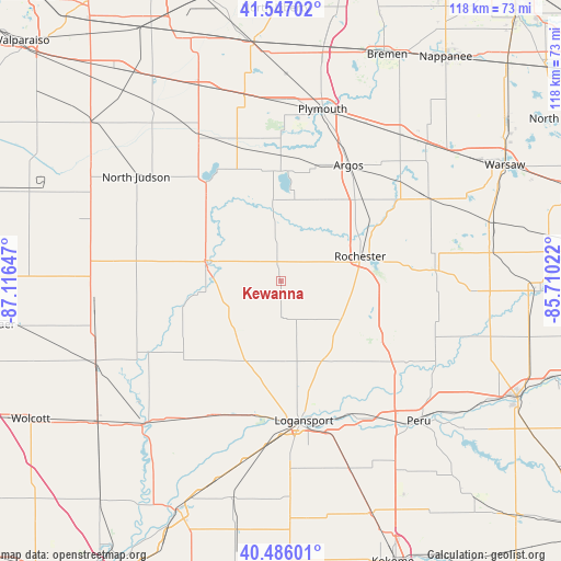
Kewanna GPS coordinates[2]
41° 1' 7.14" North, 86° 24' 48.024" West
| Map corner | latitude | longitude |
|---|---|---|
| Upper-left | 41.54702°, | -87.11647° |
| Center: | 41.01865°, | -86.41334° |
| Lower-right: | 40.48601°, | -85.71022° |
| Map W x H: | 118×118 km | = 73.3×73.3mi |
| max Lat: | 71.29058° ⇑33.9% North |
| Kewanna: | 41.01865° |
| min Lat: | ⇓66.1% South 19.06759° |
| min Long | Kewanna | max Long |
| -171.73463° | -86.41334° | -66.98998° |
| W 51.8%⇐ | ⇒48.2% E |
Elevation
Elevation of Kewanna is 240 m = 787 ft, and this is 54.8 m = 180 ft below average elevation for this country.
| Max E: |
3189 m = 10463 ft | 39.9% |
| Avg. | 294.8 m = 967 ft | |
| Kewanna | 240 m = 787 ft | |
Min E: |
-60 m = -197 ft | 60.1% |
See also: United States elevation on elevation.city.
Geographical zone
Kewanna is located in North temperate zone (between Tropic of Cancer and the Arctic Circle). Distance of this Northern Tropic circle is 1954.9 km =1214.7 mi to South.| Distance of | km | miles | from Kewanna |
|---|---|---|---|
| North Pole | 5446.2 | 3384.1 | to North |
| Arctic Circle | 2840.3 | 1764.9 | to North |
| Tropic Cancer | 1954.9 | 1214.7 | to South |
| Equator | 4560.8 | 2833.9 | to South |


Nearby cities:
15 places around Kewanna: (largest is in red/bold)
• Akron
32.4 km =20.1 mi,  86°
86°
• Argos
29.5 km =18.3 mi,  34°
34°
• Bass Lake
26.3 km =16.3 mi,  323°
323°
• Buffalo
31.7 km =19.7 mi,  241°
241°
• Culver
22.3 km =13.9 mi,  357°
357°
• Dunkirk
29.2 km =18.1 mi,  176°
176°
• Georgetown
31.9 km =19.8 mi,  193°
193°
• Knox
35.6 km =22.1 mi,  330°
330°
• Logansport
29.8 km =18.5 mi,  170°
170°
• Mentone
36.1 km =22.4 mi,  61°
61°
• Mexico
33.2 km =20.6 mi,  131°
131°
• Plymouth
37.2 km =23.1 mi,  13°
13°
• Rochester
17.3 km =10.7 mi,  72°
72°
• Royal Center
18.6 km =11.6 mi,  202°
202°
• Winamac
16.3 km =10.1 mi,  282°
282°
Sources, notices
• [Note1] Compared only with cities in United States existing in our database
• [Src1] Map data: © OpenStreetMap contributors (CC-BY-SA)
• [Src2] Other city data from geonames.org with taken over terms of usage.
• [Src3] Geographical zone / Annual Mean Temperature by Robert A. Rohde @ Wikipedia
