Knox geodata
Knox (Indiana) is a seat of a second-order administrative division; located in United States in America/Indiana/Knox (GMT-5) time zone. With population of 3,597 people, there are 8726 cities with bigger population in this country. Compared to other cities in United States, 68.8% of cities are located further ↓South; 51.2% of cities are located further ←West and 55.1% of cities have lower elevation than Knox. Note1


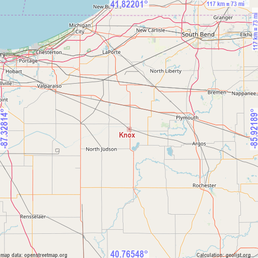
Knox GPS coordinates[2]
41° 17' 45.168" North, 86° 37' 30.036" West
| Map corner | latitude | longitude |
|---|---|---|
| Upper-left | 41.82201°, | -87.32814° |
| Center: | 41.29588°, | -86.62501° |
| Lower-right: | 40.76548°, | -85.92189° |
| Map W x H: | 117.5×117.5 km | = 73×73mi |
| max Lat: | 71.29058° ⇑31.2% North |
| Knox: | 41.29588° |
| min Lat: | ⇓68.8% South 19.06759° |
| min Long | Knox | max Long |
| -171.73463° | -86.62501° | -66.98998° |
| W 51.2%⇐ | ⇒48.8% E |
Elevation
Elevation of Knox is 219 m = 719 ft, and this is 75.8 m = 249 ft below average elevation for this country.
| Max E: |
3189 m = 10463 ft | 44.9% |
| Avg. | 294.8 m = 967 ft | |
| Knox | 219 m = 719 ft | |
Min E: |
-60 m = -197 ft | 55.1% |
See also: United States elevation on elevation.city.
Geographical zone
Knox is located in North temperate zone (between Tropic of Cancer and the Arctic Circle). Distance of this Northern Tropic circle is 1985.8 km =1233.9 mi to South.| Distance of | km | miles | from Knox |
|---|---|---|---|
| North Pole | 5415.4 | 3365 | to North |
| Arctic Circle | 2809.5 | 1745.7 | to North |
| Tropic Cancer | 1985.8 | 1233.9 | to South |
| Equator | 4591.7 | 2853.1 | to South |


Nearby cities:
15 places around Knox: (largest is in red/bold)
• Bass Lake
10 km =6.2 mi,  168°
168°
• Culver
18.9 km =11.7 mi,  116°
116°
• Fish Lake
30.7 km =19.1 mi,  11°
11°
• Hamlet
28.2 km =17.5 mi, 7°
• Kingsford Heights
21.3 km =13.2 mi,  344°
344°
• Koontz Lake
17.9 km =11.1 mi,  40°
40°
• La Crosse
22.4 km =13.9 mi,  276°
276°
• La Paz
32.1 km =19.9 mi,  55°
55°
• Medaryville
32.7 km =20.3 mi,  223°
223°
• North Judson
15.5 km =9.6 mi,  234°
234°
• North Liberty
31.2 km =19.4 mi,  31°
31°
• Plymouth
26.9 km =16.7 mi,  78°
78°
• Walkerton
22.4 km =13.9 mi, 31°
• Wanatah
27.3 km =17 mi,  303°
303°
• Winamac
27.2 km =16.9 mi,  176°
176°
Sources, notices
• [Note1] Compared only with cities in United States existing in our database
• [Src1] Map data: © OpenStreetMap contributors (CC-BY-SA)
• [Src2] Other city data from geonames.org with taken over terms of usage.
• [Src3] Geographical zone / Annual Mean Temperature by Robert A. Rohde @ Wikipedia
