South Whitley geodata
South Whitley (Indiana) is a populated place; located in United States in America/Indiana/Indianapolis (GMT-4) time zone. With population of 1,743 people, there are 12762 cities with bigger population in this country. Compared to other cities in United States, 66.7% of cities are located further ↓South; 54.1% of cities are located further ←West and 61.4% of cities have lower elevation than South Whitley. Note1


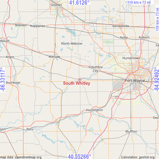
South Whitley GPS coordinates[2]
41° 5' 5.172" North, 85° 37' 40.944" West
| Map corner | latitude | longitude |
|---|---|---|
| Upper-left | 41.6126°, | -86.33117° |
| Center: | 41.08477°, | -85.62804° |
| Lower-right: | 40.55266°, | -84.92492° |
| Map W x H: | 117.9×117.9 km | = 73.3×73.3mi |
| max Lat: | 71.29058° ⇑33.3% North |
| South Whitley: | 41.08477° |
| min Lat: | ⇓66.7% South 19.06759° |
| min Long | South Whitley | max Long |
| -171.73463° | -85.62804° | -66.98998° |
| W 54.1%⇐ | ⇒45.9% E |
Elevation
Elevation of South Whitley is 246 m = 807 ft, and this is 48.8 m = 160 ft below average elevation for this country.
| Max E: |
3189 m = 10463 ft | 38.6% |
| Avg. | 294.8 m = 967 ft | |
| South Whitley | 246 m = 807 ft | |
Min E: |
-60 m = -197 ft | 61.4% |
See also: United States elevation on elevation.city.
Geographical zone
South Whitley is located in North temperate zone (between Tropic of Cancer and the Arctic Circle). Distance of this Northern Tropic circle is 1962.3 km =1219.3 mi to South.| Distance of | km | miles | from South Whitley |
|---|---|---|---|
| North Pole | 5438.9 | 3379.6 | to North |
| Arctic Circle | 2833 | 1760.3 | to North |
| Tropic Cancer | 1962.3 | 1219.3 | to South |
| Equator | 4568.2 | 2838.5 | to South |


Nearby cities:
15 places around South Whitley: (largest is in red/bold)
• Akron
33.9 km =21.1 mi,  261°
261°
• Andrews
24.8 km =15.4 mi,  174°
174°
• Churubusco
30.5 km =19 mi,  57°
57°
• Columbia City
14.2 km =8.8 mi, 55°
• Huntington
25 km =15.5 mi,  153°
153°
• Laketon
21.3 km =13.2 mi,  234°
234°
• Leesburg
33.2 km =20.6 mi,  325°
325°
• North Manchester
15.1 km =9.4 mi, 231°
• North Webster
27.4 km =17 mi,  347°
347°
• Pierceton
14.4 km =8.9 mi, 333°
• Roanoke
25.3 km =15.7 mi,  122°
122°
• Silver Lake
22.1 km =13.7 mi,  266°
266°
• Tri-Lakes
23.7 km =14.7 mi,  41°
41°
• Warsaw
25.4 km =15.8 mi,  312°
312°
• Winona Lake
22.7 km =14.1 mi, 314°
Sources, notices
• [Note1] Compared only with cities in United States existing in our database
• [Src1] Map data: © OpenStreetMap contributors (CC-BY-SA)
• [Src2] Other city data from geonames.org with taken over terms of usage.
• [Src3] Geographical zone / Annual Mean Temperature by Robert A. Rohde @ Wikipedia
