Milford geodata
Milford (Indiana) is a populated place; located in United States in America/Indiana/Indianapolis (GMT-4) time zone. With population of 1,562 people, there are 13432 cities with bigger population in this country. Compared to other cities in United States, 69.9% of cities are located further ↓South; 53.3% of cities are located further ←West and 63.5% of cities have lower elevation than Milford. Note1
Administrative division(s):
- Level 1: Indiana
- Level 2: Kosciusko County
- Level 3: Township of Van Buren


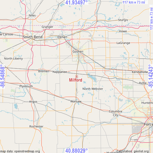
Milford GPS coordinates[2]
41° 24' 35.172" North, 85° 50' 43.98" West
| Map corner | latitude | longitude |
|---|---|---|
| Upper-left | 41.93497°, | -86.54868° |
| Center: | 41.40977°, | -85.84555° |
| Lower-right: | 40.88029°, | -85.14243° |
| Map W x H: | 117.3×117.3 km | = 72.9×72.9mi |
| max Lat: | 71.29058° ⇑30.1% North |
| Milford: | 41.40977° |
| min Lat: | ⇓69.9% South 19.06759° |
| min Long | Milford | max Long |
| -171.73463° | -85.84555° | -66.98998° |
| W 53.3%⇐ | ⇒46.7% E |
Elevation
Elevation of Milford is 255 m = 837 ft, and this is 39.8 m = 131 ft below average elevation for this country.
| Max E: |
3189 m = 10463 ft | 36.5% |
| Avg. | 294.8 m = 967 ft | |
| Milford | 255 m = 837 ft | |
Min E: |
-60 m = -197 ft | 63.5% |
See also: United States elevation on elevation.city.
Geographical zone
Milford is located in North temperate zone (between Tropic of Cancer and the Arctic Circle). Distance of this Northern Tropic circle is 1998.4 km =1241.7 mi to South.| Distance of | km | miles | from Milford |
|---|---|---|---|
| North Pole | 5402.7 | 3357.1 | to North |
| Arctic Circle | 2796.8 | 1737.9 | to North |
| Tropic Cancer | 1998.4 | 1241.7 | to South |
| Equator | 4604.3 | 2861 | to South |


Nearby cities:
15 places around Milford: (largest is in red/bold)
• Bourbon
25.9 km =16.1 mi,  240°
240°
• Bremen
25.5 km =15.8 mi,  279°
279°
• Cromwell
19.2 km =11.9 mi,  93°
93°
• Etna Green
22.2 km =13.8 mi,  229°
229°
• Goshen
19.2 km =11.9 mi,  2°
2°
• Leesburg
8.7 km =5.4 mi,  182°
182°
• Ligonier
22.4 km =13.9 mi,  73°
73°
• Millersburg
18.2 km =11.3 mi,  43°
43°
• Nappanee
13.5 km =8.4 mi,  285°
285°
• New Paris
10.2 km =6.3 mi,  8°
8°
• North Webster
15.5 km =9.6 mi,  127°
127°
• Syracuse
8 km =5 mi,  75°
75°
• Wakarusa
20.3 km =12.6 mi,  313°
313°
• Warsaw
19.1 km =11.9 mi, 181°
• Winona Lake
20.4 km =12.7 mi,  174°
174°
Sources, notices
• [Note1] Compared only with cities in United States existing in our database
• [Src1] Map data: © OpenStreetMap contributors (CC-BY-SA)
• [Src2] Other city data from geonames.org with taken over terms of usage.
• [Src3] Geographical zone / Annual Mean Temperature by Robert A. Rohde @ Wikipedia
