New Paris geodata
New Paris (Indiana) is a populated place; located in United States in America/Indiana/Indianapolis (GMT-4) time zone. With population of 1,494 people, there are 13679 cities with bigger population in this country. Compared to other cities in United States, 70.8% of cities are located further ↓South; 53.4% of cities are located further ←West and 62.4% of cities have lower elevation than New Paris. Note1


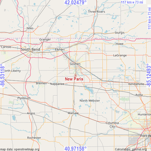
New Paris GPS coordinates[2]
41° 30' 1.188" North, 85° 49' 40.98" West
| Map corner | latitude | longitude |
|---|---|---|
| Upper-left | 42.02479°, | -86.53118° |
| Center: | 41.50033°, | -85.82805° |
| Lower-right: | 40.97158°, | -85.12493° |
| Map W x H: | 117.1×117.1 km | = 72.8×72.8mi |
| max Lat: | 71.29058° ⇑29.2% North |
| New Paris: | 41.50033° |
| min Lat: | ⇓70.8% South 19.06759° |
| min Long | New Paris | max Long |
| -171.73463° | -85.82805° | -66.98998° |
| W 53.4%⇐ | ⇒46.6% E |
Elevation
Elevation of New Paris is 250 m = 820 ft, and this is 44.8 m = 147 ft below average elevation for this country.
| Max E: |
3189 m = 10463 ft | 37.6% |
| Avg. | 294.8 m = 967 ft | |
| New Paris | 250 m = 820 ft | |
Min E: |
-60 m = -197 ft | 62.4% |
See also: United States elevation on elevation.city.
Geographical zone
New Paris is located in North temperate zone (between Tropic of Cancer and the Arctic Circle). Distance of this Northern Tropic circle is 2008.5 km =1248 mi to South.| Distance of | km | miles | from New Paris |
|---|---|---|---|
| North Pole | 5392.7 | 3350.9 | to North |
| Arctic Circle | 2786.8 | 1731.6 | to North |
| Tropic Cancer | 2008.5 | 1248 | to South |
| Equator | 4614.4 | 2867.3 | to South |


Nearby cities:
15 places around New Paris: (largest is in red/bold)
• Bristol
24.6 km =15.3 mi,  2°
2°
• Cromwell
20.9 km =13 mi,  122°
122°
• Dunlap
17.2 km =10.7 mi,  333°
333°
• Elkhart
23.7 km =14.7 mi, 328°
• Goshen
9.1 km =5.7 mi,  356°
356°
• Leesburg
18.8 km =11.7 mi,  185°
185°
• Ligonier
20.4 km =12.7 mi,  100°
100°
• Middlebury
21.9 km =13.6 mi,  27°
27°
• Milford
10.2 km =6.3 mi, 188°
• Millersburg
11.5 km =7.1 mi,  74°
74°
• Nappanee
15.8 km =9.8 mi,  246°
246°
• North Webster
22.3 km =13.9 mi,  150°
150°
• Syracuse
10.2 km =6.3 mi,  142°
142°
• Topeka
24.4 km =15.2 mi,  79°
79°
• Wakarusa
16.5 km =10.3 mi,  283°
283°
Sources, notices
• [Note1] Compared only with cities in United States existing in our database
• [Src1] Map data: © OpenStreetMap contributors (CC-BY-SA)
• [Src2] Other city data from geonames.org with taken over terms of usage.
• [Src3] Geographical zone / Annual Mean Temperature by Robert A. Rohde @ Wikipedia
