Nappanee geodata
Nappanee (Indiana) is a populated place; located in United States in America/Indiana/Indianapolis (GMT-4) time zone. With population of 6,787 people, there are 5931 cities with bigger population in this country. Compared to other cities in United States, 70.2% of cities are located further ↓South; 52.9% of cities are located further ←West and 66.3% of cities have lower elevation than Nappanee. Note1


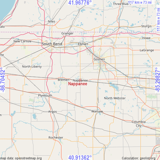
Nappanee GPS coordinates[2]
41° 26' 34.188" North, 86° 0' 5.004" West
| Map corner | latitude | longitude |
|---|---|---|
| Upper-left | 41.96776°, | -86.70452° |
| Center: | 41.44283°, | -86.00139° |
| Lower-right: | 40.91362°, | -85.29827° |
| Map W x H: | 117.2×117.2 km | = 72.8×72.8mi |
| max Lat: | 71.29058° ⇑29.8% North |
| Nappanee: | 41.44283° |
| min Lat: | ⇓70.2% South 19.06759° |
| min Long | Nappanee | max Long |
| -171.73463° | -86.00139° | -66.98998° |
| W 52.9%⇐ | ⇒47.1% E |
Elevation
Elevation of Nappanee is 268 m = 879 ft, and this is 26.8 m = 88 ft below average elevation for this country.
| Max E: |
3189 m = 10463 ft | 33.7% |
| Avg. | 294.8 m = 967 ft | |
| Nappanee | 268 m = 879 ft | |
Min E: |
-60 m = -197 ft | 66.3% |
See also: United States elevation on elevation.city.
Geographical zone
Nappanee is located in North temperate zone (between Tropic of Cancer and the Arctic Circle). Distance of this Northern Tropic circle is 2002.1 km =1244 mi to South.| Distance of | km | miles | from Nappanee |
|---|---|---|---|
| North Pole | 5399.1 | 3354.8 | to North |
| Arctic Circle | 2793.2 | 1735.6 | to North |
| Tropic Cancer | 2002.1 | 1244 | to South |
| Equator | 4608 | 2863.3 | to South |


Nearby cities:
15 places around Nappanee: (largest is in red/bold)
• Bourbon
19 km =11.8 mi,  210°
210°
• Bremen
12.2 km =7.6 mi,  271°
271°
• Dunlap
22.7 km =14.1 mi,  17°
17°
• Elkhart
26.7 km =16.6 mi,  4°
4°
• Etna Green
18.6 km =11.6 mi,  191°
191°
• Goshen
20.8 km =12.9 mi,  41°
41°
• La Paz
25.7 km =16 mi, 274°
• Lakeville
24.4 km =15.2 mi,  291°
291°
• Leesburg
17.6 km =10.9 mi,  134°
134°
• Milford
13.5 km =8.4 mi,  105°
105°
• New Paris
15.8 km =9.8 mi,  66°
66°
• Osceola
25.5 km =15.8 mi,  345°
345°
• Syracuse
20.8 km =12.9 mi,  94°
94°
• Wakarusa
10.5 km =6.5 mi, 351°
• Warsaw
25.9 km =16.1 mi,  151°
151°
Sources, notices
• [Note1] Compared only with cities in United States existing in our database
• [Src1] Map data: © OpenStreetMap contributors (CC-BY-SA)
• [Src2] Other city data from geonames.org with taken over terms of usage.
• [Src3] Geographical zone / Annual Mean Temperature by Robert A. Rohde @ Wikipedia
