Atlanta geodata
Atlanta (Indiana) is a populated place; located in United States in America/Indiana/Indianapolis (GMT-4) time zone. With population of 735 people, there are 18355 cities with bigger population in this country. Compared to other cities in United States, 55.7% of cities are located further ↓South; 52.8% of cities are located further ←West and 65.2% of cities have lower elevation than Atlanta. Note1


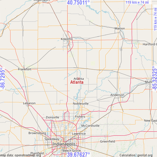
Atlanta GPS coordinates[2]
40° 12' 55.152" North, 86° 1' 34.932" West
| Map corner | latitude | longitude |
|---|---|---|
| Upper-left | 40.75011°, | -86.7295° |
| Center: | 40.21532°, | -86.02637° |
| Lower-right: | 39.67627°, | -85.32325° |
| Map W x H: | 119.4×119.4 km | = 74.2×74.2mi |
| max Lat: | 71.29058° ⇑44.3% North |
| Atlanta: | 40.21532° |
| min Lat: | ⇓55.7% South 19.06759° |
| min Long | Atlanta | max Long |
| -171.73463° | -86.02637° | -66.98998° |
| W 52.8%⇐ | ⇒47.2% E |
Elevation
Elevation of Atlanta is 263 m = 863 ft, and this is 31.8 m = 104 ft below average elevation for this country.
| Max E: |
3189 m = 10463 ft | 34.8% |
| Avg. | 294.8 m = 967 ft | |
| Atlanta | 263 m = 863 ft | |
Min E: |
-60 m = -197 ft | 65.2% |
See also: United States elevation on elevation.city.
Geographical zone
Atlanta is located in North temperate zone (between Tropic of Cancer and the Arctic Circle). Distance of this Northern Tropic circle is 1865.6 km =1159.2 mi to South.| Distance of | km | miles | from Atlanta |
|---|---|---|---|
| North Pole | 5535.5 | 3439.6 | to North |
| Arctic Circle | 2929.6 | 1820.4 | to North |
| Tropic Cancer | 1865.6 | 1159.2 | to South |
| Equator | 4471.5 | 2778.5 | to South |


Nearby cities:
15 places around Atlanta: (largest is in red/bold)
• Arcadia
4.4 km =2.7 mi,  174°
174°
• Carmel
27.5 km =17.1 mi,  196°
196°
• Cicero
10.2 km =6.3 mi, 173°
• Edgewood
27.8 km =17.3 mi,  116°
116°
• Elwood
17.1 km =10.6 mi,  66°
66°
• Frankton
21 km =13 mi,  87°
87°
• Indian Heights
25 km =15.5 mi,  340°
340°
• Kirklin
28.5 km =17.7 mi,  265°
265°
• Lapel
22.3 km =13.9 mi,  137°
137°
• Noblesville
18.9 km =11.7 mi,  175°
175°
• Sharpsville
19 km =11.8 mi, 343°
• Sheridan
18.8 km =11.7 mi,  241°
241°
• Tipton
7.5 km =4.7 mi,  350°
350°
• Westfield
21 km =13 mi, 204°
• Windfall
17.5 km =10.9 mi,  19°
19°
Sources, notices
• [Note1] Compared only with cities in United States existing in our database
• [Src1] Map data: © OpenStreetMap contributors (CC-BY-SA)
• [Src2] Other city data from geonames.org with taken over terms of usage.
• [Src3] Geographical zone / Annual Mean Temperature by Robert A. Rohde @ Wikipedia
