Van Buren geodata
Van Buren (Indiana) is a populated place; located in United States in America/Indiana/Indianapolis (GMT-4) time zone. With population of 834 people, there are 17494 cities with bigger population in this country. Compared to other cities in United States, 60.3% of cities are located further ↓South; 54.6% of cities are located further ←West and 63.9% of cities have lower elevation than Van Buren. Note1


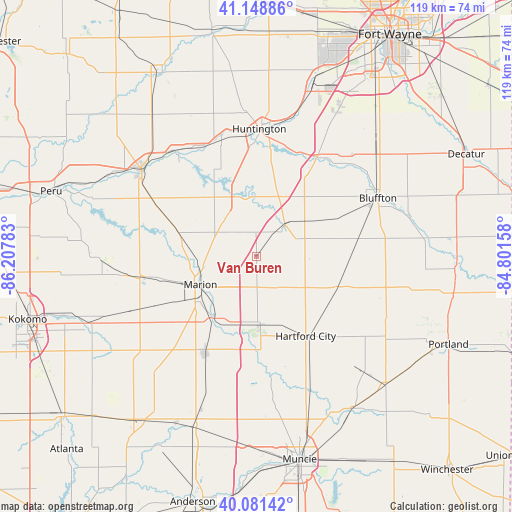
Van Buren GPS coordinates[2]
40° 37' 2.172" North, 85° 30' 16.92" West
| Map corner | latitude | longitude |
|---|---|---|
| Upper-left | 41.14886°, | -86.20783° |
| Center: | 40.61727°, | -85.5047° |
| Lower-right: | 40.08142°, | -84.80158° |
| Map W x H: | 118.7×118.7 km | = 73.8×73.8mi |
| max Lat: | 71.29058° ⇑39.7% North |
| Van Buren: | 40.61727° |
| min Lat: | ⇓60.3% South 19.06759° |
| min Long | Van Buren | max Long |
| -171.73463° | -85.5047° | -66.98998° |
| W 54.6%⇐ | ⇒45.4% E |
Elevation
Elevation of Van Buren is 257 m = 843 ft, and this is 37.8 m = 124 ft below average elevation for this country.
| Max E: |
3189 m = 10463 ft | 36.1% |
| Avg. | 294.8 m = 967 ft | |
| Van Buren | 257 m = 843 ft | |
Min E: |
-60 m = -197 ft | 63.9% |
See also: United States elevation on elevation.city.
Geographical zone
Van Buren is located in North temperate zone (between Tropic of Cancer and the Arctic Circle). Distance of this Northern Tropic circle is 1910.3 km =1187 mi to South.| Distance of | km | miles | from Van Buren |
|---|---|---|---|
| North Pole | 5490.8 | 3411.8 | to North |
| Arctic Circle | 2885 | 1792.7 | to North |
| Tropic Cancer | 1910.3 | 1187 | to South |
| Equator | 4516.2 | 2806.2 | to South |


Nearby cities:
15 places around Van Buren: (largest is in red/bold)
• Andrews
28.5 km =17.7 mi,  343°
343°
• Fairmount
25.6 km =15.9 mi,  208°
208°
• Gas City
17.1 km =10.6 mi, 212°
• Hartford City
21.7 km =13.5 mi,  148°
148°
• Huntington
29.6 km =18.4 mi,  1°
1°
• Jonesboro
18.5 km =11.5 mi, 214°
• La Fontaine
19.3 km =12 mi,  289°
289°
• Marion
14.6 km =9.1 mi,  243°
243°
• Markle
27 km =16.8 mi,  31°
31°
• Matthews
25.4 km =15.8 mi,  178°
178°
• Montpelier
20.4 km =12.7 mi,  110°
110°
• Mount Vernon
27.6 km =17.1 mi,  282°
282°
• Sweetser
22.9 km =14.2 mi,  257°
257°
• Upland
15.8 km =9.8 mi, 176°
• Warren
9.8 km =6.1 mi,  41°
41°
Sources, notices
• [Note1] Compared only with cities in United States existing in our database
• [Src1] Map data: © OpenStreetMap contributors (CC-BY-SA)
• [Src2] Other city data from geonames.org with taken over terms of usage.
• [Src3] Geographical zone / Annual Mean Temperature by Robert A. Rohde @ Wikipedia
