Warren geodata
Warren (Indiana) is a populated place; located in United States in America/Indiana/Indianapolis (GMT-4) time zone. With population of 1,223 people, there are 14995 cities with bigger population in this country. Compared to other cities in United States, 61.3% of cities are located further ↓South; 54.8% of cities are located further ←West and 63.3% of cities have lower elevation than Warren. Note1
Administrative division(s):
- Level 1: Indiana
- Level 2: Huntington County
- Level 3: Township of Salamonie


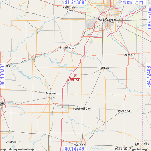
Warren GPS coordinates[2]
40° 40' 58.152" North, 85° 25' 37.92" West
| Map corner | latitude | longitude |
|---|---|---|
| Upper-left | 41.21389°, | -86.13033° |
| Center: | 40.68282°, | -85.4272° |
| Lower-right: | 40.14749°, | -84.72408° |
| Map W x H: | 118.6×118.6 km | = 73.7×73.7mi |
| max Lat: | 71.29058° ⇑38.7% North |
| Warren: | 40.68282° |
| min Lat: | ⇓61.3% South 19.06759° |
| min Long | Warren | max Long |
| -171.73463° | -85.4272° | -66.98998° |
| W 54.8%⇐ | ⇒45.2% E |
Elevation
Elevation of Warren is 254 m = 833 ft, and this is 40.8 m = 134 ft below average elevation for this country.
| Max E: |
3189 m = 10463 ft | 36.7% |
| Avg. | 294.8 m = 967 ft | |
| Warren | 254 m = 833 ft | |
Min E: |
-60 m = -197 ft | 63.3% |
See also: United States elevation on elevation.city.
Geographical zone
Warren is located in North temperate zone (between Tropic of Cancer and the Arctic Circle). Distance of this Northern Tropic circle is 1917.6 km =1191.5 mi to South.| Distance of | km | miles | from Warren |
|---|---|---|---|
| North Pole | 5483.6 | 3407.4 | to North |
| Arctic Circle | 2877.7 | 1788.1 | to North |
| Tropic Cancer | 1917.6 | 1191.5 | to South |
| Equator | 4523.5 | 2810.8 | to South |


Nearby cities:
15 places around Warren: (largest is in red/bold)
• Andrews
24.8 km =15.4 mi,  323°
323°
• Bluffton
22.4 km =13.9 mi,  73°
73°
• Gas City
26.8 km =16.7 mi,  215°
215°
• Hartford City
26.2 km =16.3 mi,  169°
169°
• Huntington
23 km =14.3 mi,  345°
345°
• Jonesboro
28.2 km =17.5 mi, 216°
• La Fontaine
24.8 km =15.4 mi,  267°
267°
• Marion
24 km =14.9 mi,  234°
234°
• Markle
17.4 km =10.8 mi,  25°
25°
• Montpelier
19.1 km =11.9 mi,  138°
138°
• Ossian
31.1 km =19.3 mi,  44°
44°
• Roanoke
31.4 km =19.5 mi,  8°
8°
• Upland
23.7 km =14.7 mi,  193°
193°
• Van Buren
9.8 km =6.1 mi, 221°
• Zanesville
28.8 km =17.9 mi, 25°
Sources, notices
• [Note1] Compared only with cities in United States existing in our database
• [Src1] Map data: © OpenStreetMap contributors (CC-BY-SA)
• [Src2] Other city data from geonames.org with taken over terms of usage.
• [Src3] Geographical zone / Annual Mean Temperature by Robert A. Rohde @ Wikipedia
