Walton geodata
Walton (Indiana) is a populated place; located in United States in America/Indiana/Indianapolis (GMT-4) time zone. With population of 1,022 people, there are 16139 cities with bigger population in this country. Compared to other cities in United States, 61% of cities are located further ↓South; 52.3% of cities are located further ←West and 59.4% of cities have lower elevation than Walton. Note1


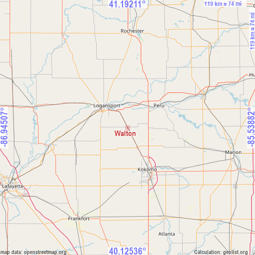
Walton GPS coordinates[2]
40° 39' 39.132" North, 86° 14' 30.984" West
| Map corner | latitude | longitude |
|---|---|---|
| Upper-left | 41.19211°, | -86.94507° |
| Center: | 40.66087°, | -86.24194° |
| Lower-right: | 40.12536°, | -85.53882° |
| Map W x H: | 118.6×118.6 km | = 73.7×73.7mi |
| max Lat: | 71.29058° ⇑39% North |
| Walton: | 40.66087° |
| min Lat: | ⇓61% South 19.06759° |
| min Long | Walton | max Long |
| -171.73463° | -86.24194° | -66.98998° |
| W 52.3%⇐ | ⇒47.7% E |
Elevation
Elevation of Walton is 237 m = 778 ft, and this is 57.8 m = 190 ft below average elevation for this country.
| Max E: |
3189 m = 10463 ft | 40.6% |
| Avg. | 294.8 m = 967 ft | |
| Walton | 237 m = 778 ft | |
Min E: |
-60 m = -197 ft | 59.4% |
See also: United States elevation on elevation.city.
Geographical zone
Walton is located in North temperate zone (between Tropic of Cancer and the Arctic Circle). Distance of this Northern Tropic circle is 1915.1 km =1190 mi to South.| Distance of | km | miles | from Walton |
|---|---|---|---|
| North Pole | 5486 | 3408.8 | to North |
| Arctic Circle | 2880.1 | 1789.6 | to North |
| Tropic Cancer | 1915.1 | 1190 | to South |
| Equator | 4521.1 | 2809.3 | to South |


Nearby cities:
15 places around Walton: (largest is in red/bold)
• Bunker Hill
11.7 km =7.3 mi,  90°
90°
• Burlington
23.9 km =14.9 mi,  212°
212°
• Camden
25.8 km =16 mi,  257°
257°
• Dunkirk
16.6 km =10.3 mi,  309°
309°
• Flora
27 km =16.8 mi,  242°
242°
• Galveston
10.1 km =6.3 mi,  154°
154°
• Georgetown
23.9 km =14.9 mi,  291°
291°
• Greentown
30.9 km =19.2 mi,  131°
131°
• Grissom Air Force Base
8 km =5 mi, 92°
• Indian Heights
27.8 km =17.3 mi,  159°
159°
• Kokomo
21.4 km =13.3 mi, 154°
• Logansport
14.2 km =8.8 mi,  317°
317°
• Mexico
20.9 km =13 mi,  30°
30°
• Peru
17.9 km =11.1 mi,  54°
54°
• Russiaville
27.2 km =16.9 mi,  185°
185°
Sources, notices
• [Note1] Compared only with cities in United States existing in our database
• [Src1] Map data: © OpenStreetMap contributors (CC-BY-SA)
• [Src2] Other city data from geonames.org with taken over terms of usage.
• [Src3] Geographical zone / Annual Mean Temperature by Robert A. Rohde @ Wikipedia
