Flora geodata
Flora (Indiana) is a populated place; located in United States in America/Indiana/Indianapolis (GMT-4) time zone. With population of 1,985 people, there are 11984 cities with bigger population in this country. Compared to other cities in United States, 59.3% of cities are located further ↓South; 51.5% of cities are located further ←West and 54.4% of cities have lower elevation than Flora. Note1


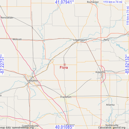
Flora GPS coordinates[2]
40° 32' 50.136" North, 86° 31' 27.984" West
| Map corner | latitude | longitude |
|---|---|---|
| Upper-left | 41.07941°, | -87.22757° |
| Center: | 40.54726°, | -86.52444° |
| Lower-right: | 40.01085°, | -85.82132° |
| Map W x H: | 118.8×118.8 km | = 73.8×73.8mi |
| max Lat: | 71.29058° ⇑40.7% North |
| Flora: | 40.54726° |
| min Lat: | ⇓59.3% South 19.06759° |
| min Long | Flora | max Long |
| -171.73463° | -86.52444° | -66.98998° |
| W 51.5%⇐ | ⇒48.5% E |
Elevation
Elevation of Flora is 216 m = 709 ft, and this is 78.8 m = 259 ft below average elevation for this country.
| Max E: |
3189 m = 10463 ft | 45.6% |
| Avg. | 294.8 m = 967 ft | |
| Flora | 216 m = 709 ft | |
Min E: |
-60 m = -197 ft | 54.4% |
See also: United States elevation on elevation.city.
Geographical zone
Flora is located in North temperate zone (between Tropic of Cancer and the Arctic Circle). Distance of this Northern Tropic circle is 1902.5 km =1182.2 mi to South.| Distance of | km | miles | from Flora |
|---|---|---|---|
| North Pole | 5498.6 | 3416.7 | to North |
| Arctic Circle | 2892.7 | 1797.4 | to North |
| Tropic Cancer | 1902.5 | 1182.2 | to South |
| Equator | 4508.4 | 2801.4 | to South |


Nearby cities:
15 places around Flora: (largest is in red/bold)
• Battle Ground
27.2 km =16.9 mi,  260°
260°
• Brookston
29.6 km =18.4 mi,  282°
282°
• Burlington
13.3 km =8.3 mi,  124°
124°
• Camden
7 km =4.3 mi,  349°
349°
• Dayton
28.2 km =17.5 mi,  227°
227°
• Delphi
13.5 km =8.4 mi,  289°
289°
• Dunkirk
25.7 km =16 mi,  25°
25°
• Frankfort
29.8 km =18.5 mi,  177°
177°
• Galveston
28.4 km =17.6 mi,  82°
82°
• Georgetown
21.6 km =13.4 mi,  4°
4°
• Logansport
27 km =16.8 mi, 31°
• Mulberry
25.5 km =15.8 mi,  207°
207°
• Rossville
15.7 km =9.8 mi,  202°
202°
• Russiaville
25.8 km =16 mi, 123°
• Walton
27 km =16.8 mi,  62°
62°
Sources, notices
• [Note1] Compared only with cities in United States existing in our database
• [Src1] Map data: © OpenStreetMap contributors (CC-BY-SA)
• [Src2] Other city data from geonames.org with taken over terms of usage.
• [Src3] Geographical zone / Annual Mean Temperature by Robert A. Rohde @ Wikipedia
