Ayer geodata
Ayer (Massachusetts) is a populated place; located in United States in America/New_York (GMT-4) time zone. With population of 2,868 people, there are 9878 cities with bigger population in this country. Compared to other cities in United States, 80.3% of cities are located further ↓South; 96.4% of cities are located further ←West and 74.4% of cities have higher elevation than Ayer. Note1


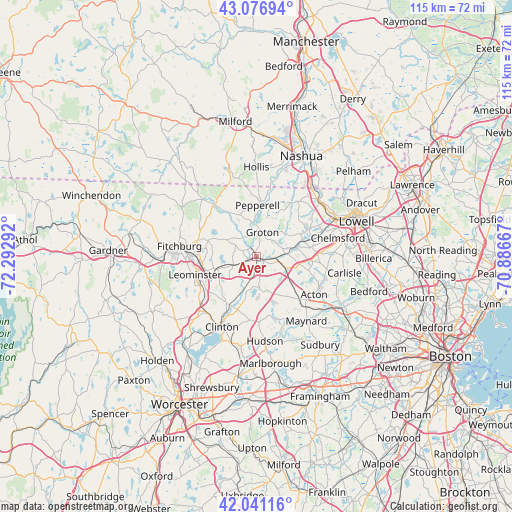
Ayer GPS coordinates[2]
42° 33' 40.32" North, 71° 35' 23.244" West
| Map corner | latitude | longitude |
|---|---|---|
| Upper-left | 43.07694°, | -72.29292° |
| Center: | 42.5612°, | -71.58979° |
| Lower-right: | 42.04116°, | -70.88667° |
| Map W x H: | 115.2×115.2 km | = 71.6×71.6mi |
| max Lat: | 71.29058° ⇑19.7% North |
| Ayer: | 42.5612° |
| min Lat: | ⇓80.3% South 19.06759° |
| min Long | Ayer | max Long |
| -171.73463° | -71.58979° | -66.98998° |
| W 96.4%⇐ | ⇒3.6% E |
Elevation
Elevation of Ayer is 75 m = 246 ft, and this is 219.8 m = 721 ft below average elevation for this country.
| Max E: |
3189 m = 10463 ft | 74.4% |
| Avg. | 294.8 m = 967 ft | |
| Ayer | 75 m = 246 ft | |
Min E: |
-60 m = -197 ft | 25.6% |
See also: United States elevation on elevation.city.
Geographical zone
Ayer is located in North temperate zone (between Tropic of Cancer and the Arctic Circle). Distance of this Northern Tropic circle is 2126.4 km =1321.3 mi to South.| Distance of | km | miles | from Ayer |
|---|---|---|---|
| North Pole | 5274.7 | 3277.5 | to North |
| Arctic Circle | 2668.8 | 1658.3 | to North |
| Tropic Cancer | 2126.4 | 1321.3 | to South |
| Equator | 4732.4 | 2940.6 | to South |


Nearby cities:
15 places around Ayer: (largest is in red/bold)
• Bolton
14.3 km =8.9 mi,  185°
185°
• Boxborough
9.3 km =5.8 mi,  147°
147°
• Devens
2.7 km =1.7 mi,  226°
226°
• East Pepperell
11.7 km =7.3 mi,  6°
6°
• Groton
5.7 km =3.5 mi, 12°
• Harvard
6.8 km =4.2 mi,  175°
175°
• Lancaster
13.6 km =8.5 mi,  210°
210°
• Leominster
14.5 km =9 mi,  253°
253°
• Littleton Common
9.6 km =6 mi,  100°
100°
• Lunenburg
11.6 km =7.2 mi,  288°
288°
• Pepperell
11.6 km =7.2 mi,  0°
0°
• Shirley
5.3 km =3.3 mi, 248°
• South Lancaster
15.2 km =9.4 mi, 211°
• Townsend
15.1 km =9.4 mi,  321°
321°
• Westford
12.6 km =7.8 mi,  80°
80°
Sources, notices
• [Note1] Compared only with cities in United States existing in our database
• [Src1] Map data: © OpenStreetMap contributors (CC-BY-SA)
• [Src2] Other city data from geonames.org with taken over terms of usage.
• [Src3] Geographical zone / Annual Mean Temperature by Robert A. Rohde @ Wikipedia
