Lunenburg geodata
Lunenburg (Massachusetts) is a populated place; located in United States in America/New_York (GMT-4) time zone. With population of 1,760 people, there are 12701 cities with bigger population in this country. Compared to other cities in United States, 80.5% of cities are located further ↓South; 96.2% of cities are located further ←West and 55.7% of cities have higher elevation than Lunenburg. Note1
Administrative division(s):
- Level 1: Massachusetts
- Level 2: Worcester County
- Level 3: Town of Lunenburg


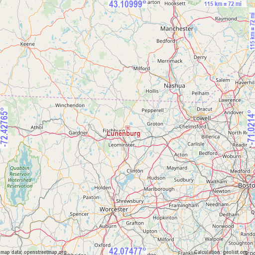
Lunenburg GPS coordinates[2]
42° 35' 40.308" North, 71° 43' 28.272" West
| Map corner | latitude | longitude |
|---|---|---|
| Upper-left | 43.10999°, | -72.42765° |
| Center: | 42.59453°, | -71.72452° |
| Lower-right: | 42.07477°, | -71.0214° |
| Map W x H: | 115.1×115.1 km | = 71.5×71.5mi |
| max Lat: | 71.29058° ⇑19.5% North |
| Lunenburg: | 42.59453° |
| min Lat: | ⇓80.5% South 19.06759° |
| min Long | Lunenburg | max Long |
| -171.73463° | -71.72452° | -66.98998° |
| W 96.2%⇐ | ⇒3.8% E |
Elevation
Elevation of Lunenburg is 177 m = 581 ft, and this is 117.8 m = 386 ft below average elevation for this country.
| Max E: |
3189 m = 10463 ft | 55.7% |
| Avg. | 294.8 m = 967 ft | |
| Lunenburg | 177 m = 581 ft | |
Min E: |
-60 m = -197 ft | 44.3% |
See also: United States elevation on elevation.city.
Geographical zone
Lunenburg is located in North temperate zone (between Tropic of Cancer and the Arctic Circle). Distance of this Northern Tropic circle is 2130.1 km =1323.6 mi to South.| Distance of | km | miles | from Lunenburg |
|---|---|---|---|
| North Pole | 5271 | 3275.2 | to North |
| Arctic Circle | 2665.1 | 1656 | to North |
| Tropic Cancer | 2130.1 | 1323.6 | to South |
| Equator | 4736.1 | 2942.9 | to South |


Nearby cities:
15 places around Lunenburg: (largest is in red/bold)
• Ashburnham
15.7 km =9.8 mi,  287°
287°
• Ashby
12.1 km =7.5 mi,  319°
319°
• Ayer
11.6 km =7.2 mi,  108°
108°
• Brookline
16.5 km =10.3 mi,  19°
19°
• Devens
10.7 km =6.6 mi,  121°
121°
• East Pepperell
14.7 km =9.1 mi,  57°
57°
• Fitchburg
6.5 km =4 mi,  259°
259°
• Groton
12.4 km =7.7 mi,  81°
81°
• Harvard
15.7 km =9.8 mi,  132°
132°
• Lancaster
16 km =9.9 mi,  164°
164°
• Leominster
8.2 km =5.1 mi,  200°
200°
• Pepperell
13.7 km =8.5 mi,  54°
54°
• Shirley
8.3 km =5.2 mi, 132°
• Townsend
8.2 km =5.1 mi,  11°
11°
• Westminster
16.2 km =10.1 mi,  250°
250°
Sources, notices
• [Note1] Compared only with cities in United States existing in our database
• [Src1] Map data: © OpenStreetMap contributors (CC-BY-SA)
• [Src2] Other city data from geonames.org with taken over terms of usage.
• [Src3] Geographical zone / Annual Mean Temperature by Robert A. Rohde @ Wikipedia
