Carver geodata
Carver (Massachusetts) is a populated place; located in United States in America/New_York (GMT-4) time zone. With population of 11,718 people, there are 3960 cities with bigger population in this country. Compared to other cities in United States, 74.6% of cities are located further ↓South; 98.1% of cities are located further ←West and 82.9% of cities have higher elevation than Carver. Note1


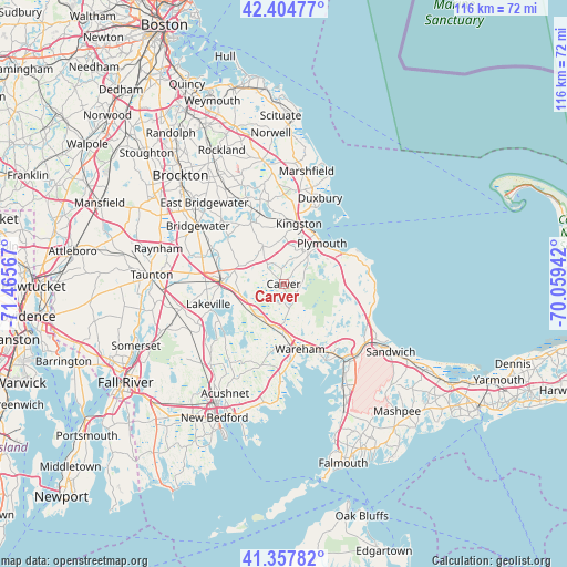
Carver GPS coordinates[2]
41° 53' 0.384" North, 70° 45' 45.144" West
| Map corner | latitude | longitude |
|---|---|---|
| Upper-left | 42.40477°, | -71.46567° |
| Center: | 41.88344°, | -70.76254° |
| Lower-right: | 41.35782°, | -70.05942° |
| Map W x H: | 116.4×116.4 km | = 72.3×72.3mi |
| max Lat: | 71.29058° ⇑25.4% North |
| Carver: | 41.88344° |
| min Lat: | ⇓74.6% South 19.06759° |
| min Long | Carver | max Long |
| -171.73463° | -70.76254° | -66.98998° |
| W 98.1%⇐ | ⇒1.9% E |
Elevation
Elevation of Carver is 35 m = 115 ft, and this is 259.8 m = 852 ft below average elevation for this country.
| Max E: |
3189 m = 10463 ft | 82.9% |
| Avg. | 294.8 m = 967 ft | |
| Carver | 35 m = 115 ft | |
Min E: |
-60 m = -197 ft | 17.1% |
See also: United States elevation on elevation.city.
Geographical zone
Carver is located in North temperate zone (between Tropic of Cancer and the Arctic Circle). Distance of this Northern Tropic circle is 2051.1 km =1274.5 mi to South.| Distance of | km | miles | from Carver |
|---|---|---|---|
| North Pole | 5350.1 | 3324.4 | to North |
| Arctic Circle | 2744.2 | 1705.2 | to North |
| Tropic Cancer | 2051.1 | 1274.5 | to South |
| Equator | 4657 | 2893.7 | to South |


Nearby cities:
15 places around Carver: (largest is in red/bold)
• Halifax
14.5 km =9 mi,  325°
325°
• Kingston
12.7 km =7.9 mi,  14°
14°
• Middleborough
12.3 km =7.6 mi,  275°
275°
• Middleborough Center
13.6 km =8.5 mi, 275°
• North Lakeville
15.2 km =9.4 mi,  259°
259°
• North Plymouth
11.8 km =7.3 mi,  34°
34°
• Plymouth
11.5 km =7.1 mi,  43°
43°
• Plympton
8.8 km =5.5 mi, 330°
• Rochester
17.5 km =10.9 mi,  195°
195°
• South Duxbury
16.9 km =10.5 mi,  22°
22°
• The Pinehills
13.5 km =8.4 mi,  87°
87°
• Wareham Center
13.3 km =8.3 mi,  166°
166°
• West Wareham
10.4 km =6.5 mi,  178°
178°
• Weweantic
16.7 km =10.4 mi, 171°
• White Island Shores
14.1 km =8.8 mi,  131°
131°
Sources, notices
• [Note1] Compared only with cities in United States existing in our database
• [Src1] Map data: © OpenStreetMap contributors (CC-BY-SA)
• [Src2] Other city data from geonames.org with taken over terms of usage.
• [Src3] Geographical zone / Annual Mean Temperature by Robert A. Rohde @ Wikipedia
