Haverhill geodata
Haverhill (Massachusetts) is a populated place; located in United States in America/New_York (GMT-4) time zone. With population of 62,765 people, there are 696 cities with bigger population in this country. Compared to other cities in United States, 81.7% of cities are located further ↓South; 97.5% of cities are located further ←West and 89.1% of cities have higher elevation than Haverhill. Note1


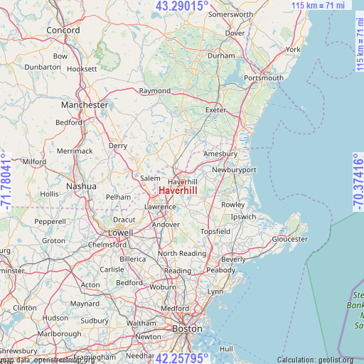
Haverhill GPS coordinates[2]
42° 46' 34.32" North, 71° 4' 38.208" West
| Map corner | latitude | longitude |
|---|---|---|
| Upper-left | 43.29015°, | -71.78041° |
| Center: | 42.7762°, | -71.07728° |
| Lower-right: | 42.25795°, | -70.37416° |
| Map W x H: | 114.8×114.8 km | = 71.3×71.3mi |
| max Lat: | 71.29058° ⇑18.3% North |
| Haverhill: | 42.7762° |
| min Lat: | ⇓81.7% South 19.06759° |
| min Long | Haverhill | max Long |
| -171.73463° | -71.07728° | -66.98998° |
| W 97.5%⇐ | ⇒2.5% E |
Elevation
Elevation of Haverhill is 18 m = 59 ft, and this is 276.8 m = 908 ft below average elevation for this country.
| Max E: |
3189 m = 10463 ft | 89.1% |
| Avg. | 294.8 m = 967 ft | |
| Haverhill | 18 m = 59 ft | |
Min E: |
-60 m = -197 ft | 10.9% |
See also: Haverhill elevation on elevation.city.
Geographical zone
Haverhill is located in North temperate zone (between Tropic of Cancer and the Arctic Circle). Distance of this Northern Tropic circle is 2150.3 km =1336.1 mi to South.| Distance of | km | miles | from Haverhill |
|---|---|---|---|
| North Pole | 5250.8 | 3262.7 | to North |
| Arctic Circle | 2644.9 | 1643.5 | to North |
| Tropic Cancer | 2150.3 | 1336.1 | to South |
| Equator | 4756.3 | 2955.4 | to South |


Nearby cities:
15 places around Haverhill: (largest is in red/bold)
• Amesbury
15.1 km =9.4 mi,  52°
52°
• Andover
14 km =8.7 mi,  200°
200°
• Atkinson
9 km =5.6 mi,  320°
320°
• Boxford
14.4 km =8.9 mi,  152°
152°
• Groveland
4.1 km =2.5 mi,  115°
115°
• Hampstead
13.8 km =8.6 mi, 322°
• Lawrence
10.4 km =6.5 mi,  222°
222°
• Merrimac
8.6 km =5.3 mi, 45°
• Methuen
10.8 km =6.7 mi,  239°
239°
• Newton
10.9 km =6.8 mi,  18°
18°
• North Andover
9.8 km =6.1 mi,  208°
208°
• Plaistow
6.9 km =4.3 mi,  347°
347°
• Salem
10.2 km =6.3 mi,  277°
277°
• South Hampton
14.9 km =9.3 mi,  38°
38°
• West Newbury
7.7 km =4.8 mi,  68°
68°
Sources, notices
• [Note1] Compared only with cities in United States existing in our database
• [Src1] Map data: © OpenStreetMap contributors (CC-BY-SA)
• [Src2] Other city data from geonames.org with taken over terms of usage.
• [Src3] Geographical zone / Annual Mean Temperature by Robert A. Rohde @ Wikipedia
