Lawrence geodata
Lawrence (Massachusetts) is a populated place; located in United States in America/New_York (GMT-4) time zone. With population of 80,231 people, there are 493 cities with bigger population in this country. Compared to other cities in United States, 81.3% of cities are located further ↓South; 97.3% of cities are located further ←West and 88.2% of cities have higher elevation than Lawrence. Note1


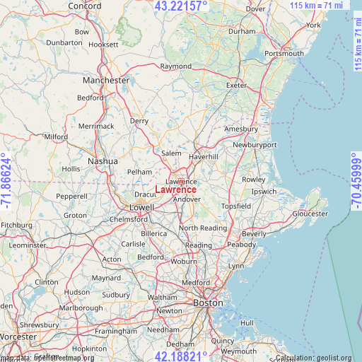
Lawrence GPS coordinates[2]
42° 42' 25.344" North, 71° 9' 47.196" West
| Map corner | latitude | longitude |
|---|---|---|
| Upper-left | 43.22157°, | -71.86624° |
| Center: | 42.70704°, | -71.16311° |
| Lower-right: | 42.18821°, | -70.45999° |
| Map W x H: | 114.9×114.9 km | = 71.4×71.4mi |
| max Lat: | 71.29058° ⇑18.7% North |
| Lawrence: | 42.70704° |
| min Lat: | ⇓81.3% South 19.06759° |
| min Long | Lawrence | max Long |
| -171.73463° | -71.16311° | -66.98998° |
| W 97.3%⇐ | ⇒2.7% E |
Elevation
Elevation of Lawrence is 20 m = 66 ft, and this is 274.8 m = 902 ft below average elevation for this country.
| Max E: |
3189 m = 10463 ft | 88.2% |
| Avg. | 294.8 m = 967 ft | |
| Lawrence | 20 m = 66 ft | |
Min E: |
-60 m = -197 ft | 11.8% |
See also: Lawrence elevation on elevation.city.
Geographical zone
Lawrence is located in North temperate zone (between Tropic of Cancer and the Arctic Circle). Distance of this Northern Tropic circle is 2142.7 km =1331.4 mi to South.| Distance of | km | miles | from Lawrence |
|---|---|---|---|
| North Pole | 5258.5 | 3267.5 | to North |
| Arctic Circle | 2652.6 | 1648.2 | to North |
| Tropic Cancer | 2142.7 | 1331.4 | to South |
| Equator | 4748.6 | 2950.6 | to South |


Nearby cities:
15 places around Lawrence: (largest is in red/bold)
• Andover
5.8 km =3.6 mi,  158°
158°
• Atkinson
14.7 km =9.1 mi,  5°
5°
• Boxford
14.5 km =9 mi,  110°
110°
• Dracut
12.1 km =7.5 mi,  250°
250°
• Groveland
12.3 km =7.6 mi,  61°
61°
• Haverhill
10.4 km =6.5 mi,  42°
42°
• Lowell
15 km =9.3 mi,  236°
236°
• Methuen
3.1 km =1.9 mi,  313°
313°
• North Andover
2.5 km =1.6 mi, 112°
• North Reading
16.2 km =10.1 mi,  154°
154°
• Pelham
13.5 km =8.4 mi,  283°
283°
• Plaistow
15.4 km =9.6 mi,  21°
21°
• Salem
9.6 km =6 mi,  341°
341°
• Tewksbury
12.2 km =7.6 mi,  208°
208°
• Windham
15.5 km =9.6 mi, 312°
Sources, notices
• [Note1] Compared only with cities in United States existing in our database
• [Src1] Map data: © OpenStreetMap contributors (CC-BY-SA)
• [Src2] Other city data from geonames.org with taken over terms of usage.
• [Src3] Geographical zone / Annual Mean Temperature by Robert A. Rohde @ Wikipedia
