North Pembroke geodata
North Pembroke (Massachusetts) is a populated place; located in United States in America/New_York (GMT-4) time zone. With population of 3,292 people, there are 9162 cities with bigger population in this country. Compared to other cities in United States, 76.4% of cities are located further ↓South; 98% of cities are located further ←West and 86.2% of cities have higher elevation than North Pembroke. Note1
Administrative division(s):
- Level 1: Massachusetts
- Level 2: Plymouth County
- Level 3: Town of Pembroke


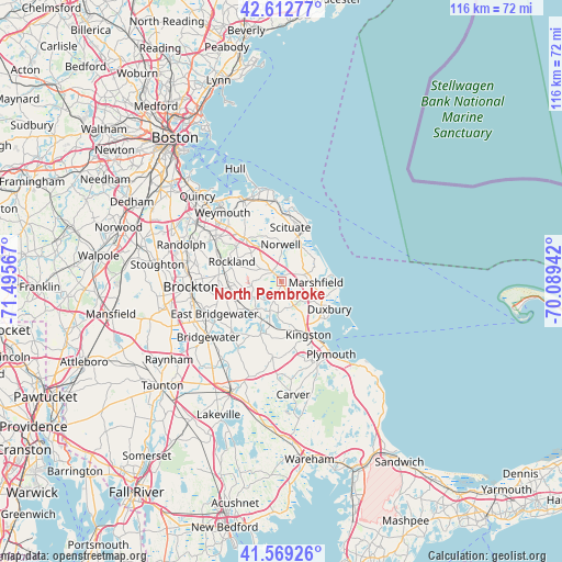
North Pembroke GPS coordinates[2]
42° 5' 35.376" North, 70° 47' 33.144" West
| Map corner | latitude | longitude |
|---|---|---|
| Upper-left | 42.61277°, | -71.49567° |
| Center: | 42.09316°, | -70.79254° |
| Lower-right: | 41.56926°, | -70.08942° |
| Map W x H: | 116×116 km | = 72.1×72.1mi |
| max Lat: | 71.29058° ⇑23.6% North |
| North Pembroke: | 42.09316° |
| min Lat: | ⇓76.4% South 19.06759° |
| min Long | North Pembroke | max Long |
| -171.73463° | -70.79254° | -66.98998° |
| W 98%⇐ | ⇒2% E |
Elevation
Elevation of North Pembroke is 25 m = 82 ft, and this is 269.8 m = 885 ft below average elevation for this country.
| Max E: |
3189 m = 10463 ft | 86.2% |
| Avg. | 294.8 m = 967 ft | |
| North Pembroke | 25 m = 82 ft | |
Min E: |
-60 m = -197 ft | 13.8% |
See also: United States elevation on elevation.city.
Geographical zone
North Pembroke is located in North temperate zone (between Tropic of Cancer and the Arctic Circle). Distance of this Northern Tropic circle is 2074.4 km =1289 mi to South.| Distance of | km | miles | from North Pembroke |
|---|---|---|---|
| North Pole | 5326.7 | 3309.9 | to North |
| Arctic Circle | 2720.9 | 1690.7 | to North |
| Tropic Cancer | 2074.4 | 1289 | to South |
| Equator | 4680.3 | 2908.2 | to South |


Nearby cities:
15 places around North Pembroke: (largest is in red/bold)
• Abington
12.7 km =7.9 mi,  275°
275°
• Duxbury
11.5 km =7.1 mi,  119°
119°
• Green Harbor-Cedar Crest
11.3 km =7 mi,  100°
100°
• Halifax
12.7 km =7.9 mi,  206°
206°
• Hanover
2.7 km =1.7 mi,  324°
324°
• Hanson
7.5 km =4.7 mi,  254°
254°
• Kingston
12.3 km =7.6 mi,  152°
152°
• Marshfield
7.2 km =4.5 mi,  91°
91°
• Marshfield Hills
7.3 km =4.5 mi,  36°
36°
• Norwell
7.6 km =4.7 mi,  359°
359°
• Ocean Bluff-Brant Rock
11.2 km =7 mi,  84°
84°
• Rockland
11 km =6.8 mi,  292°
292°
• Scituate
12.7 km =7.9 mi,  25°
25°
• South Duxbury
11.9 km =7.4 mi,  130°
130°
• Whitman
11.9 km =7.4 mi,  263°
263°
Sources, notices
• [Note1] Compared only with cities in United States existing in our database
• [Src1] Map data: © OpenStreetMap contributors (CC-BY-SA)
• [Src2] Other city data from geonames.org with taken over terms of usage.
• [Src3] Geographical zone / Annual Mean Temperature by Robert A. Rohde @ Wikipedia
