Phillipston geodata
Phillipston (Massachusetts) is a populated place; located in United States in America/New_York (GMT-4) time zone. With population of 1,649 people, there are 13087 cities with bigger population in this country. Compared to other cities in United States, 80.2% of cities are located further ↓South; 95.5% of cities are located further ←West and 80.5% of cities have lower elevation than Phillipston. Note1
Administrative division(s):
- Level 1: Massachusetts
- Level 2: Worcester County
- Level 3: Town of Phillipston


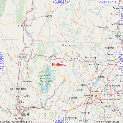
Phillipston GPS coordinates[2]
42° 32' 55.32" North, 72° 7' 58.296" West
| Map corner | latitude | longitude |
|---|---|---|
| Upper-left | 43.06454°, | -72.83599° |
| Center: | 42.5487°, | -72.13286° |
| Lower-right: | 42.02856°, | -71.42974° |
| Map W x H: | 115.2×115.2 km | = 71.6×71.6mi |
| max Lat: | 71.29058° ⇑19.8% North |
| Phillipston: | 42.5487° |
| min Lat: | ⇓80.2% South 19.06759° |
| min Long | Phillipston | max Long |
| -171.73463° | -72.13286° | -66.98998° |
| W 95.5%⇐ | ⇒4.5% E |
Elevation
Elevation of Phillipston is 358 m = 1175 ft, and this is 63.2 m = 207 ft above average elevation for this country.
| Max E: |
3189 m = 10463 ft | 19.5% |
| Phillipston | 358 m 1175 ft | |
| Avg. | 294.8 m = 967 ft | |
Min E: |
-60 m = -197 ft | 80.5% |
See also: United States elevation on elevation.city.
Geographical zone
Phillipston is located in North temperate zone (between Tropic of Cancer and the Arctic Circle). Distance of this Northern Tropic circle is 2125.1 km =1320.5 mi to South.| Distance of | km | miles | from Phillipston |
|---|---|---|---|
| North Pole | 5276.1 | 3278.4 | to North |
| Arctic Circle | 2670.2 | 1659.2 | to North |
| Tropic Cancer | 2125.1 | 1320.5 | to South |
| Equator | 4731 | 2939.7 | to South |


Nearby cities:
15 places around Phillipston: (largest is in red/bold)
• Ashburnham
20.8 km =12.9 mi,  62°
62°
• Athol
9.3 km =5.8 mi,  304°
304°
• Baldwinville
8.1 km =5 mi,  35°
35°
• Barre
14.2 km =8.8 mi,  170°
170°
• Erving
22.5 km =14 mi,  284°
284°
• Gardner
11.4 km =7.1 mi,  75°
75°
• Hubbardston
13.3 km =8.3 mi,  128°
128°
• New Salem
17.1 km =10.6 mi,  253°
253°
• Orange
15.2 km =9.4 mi,  287°
287°
• Royalston
15 km =9.3 mi,  342°
342°
• South Ashburnham
17.3 km =10.7 mi,  66°
66°
• Templeton
5.4 km =3.4 mi, 81°
• Wendell
21.6 km =13.4 mi,  269°
269°
• Westminster
18.2 km =11.3 mi,  90°
90°
• Winchendon
16.9 km =10.5 mi,  25°
25°
Sources, notices
• [Note1] Compared only with cities in United States existing in our database
• [Src1] Map data: © OpenStreetMap contributors (CC-BY-SA)
• [Src2] Other city data from geonames.org with taken over terms of usage.
• [Src3] Geographical zone / Annual Mean Temperature by Robert A. Rohde @ Wikipedia
