Barre geodata
Barre (Massachusetts) is a populated place; located in United States in America/New_York (GMT-4) time zone. With population of 1,009 people, there are 16228 cities with bigger population in this country. Compared to other cities in United States, 79.1% of cities are located further ↓South; 95.5% of cities are located further ←West and 68% of cities have lower elevation than Barre. Note1


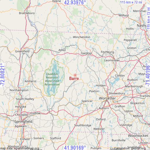
Barre GPS coordinates[2]
42° 25' 22.332" North, 72° 6' 18.288" West
| Map corner | latitude | longitude |
|---|---|---|
| Upper-left | 42.93976°, | -72.80821° |
| Center: | 42.42287°, | -72.10508° |
| Lower-right: | 41.90169°, | -71.40196° |
| Map W x H: | 115.4×115.4 km | = 71.7×71.7mi |
| max Lat: | 71.29058° ⇑20.9% North |
| Barre: | 42.42287° |
| min Lat: | ⇓79.1% South 19.06759° |
| min Long | Barre | max Long |
| -171.73463° | -72.10508° | -66.98998° |
| W 95.5%⇐ | ⇒4.5% E |
Elevation
Elevation of Barre is 276 m = 906 ft, and this is 18.8 m = 62 ft below average elevation for this country.
| Max E: |
3189 m = 10463 ft | 32% |
| Avg. | 294.8 m = 967 ft | |
| Barre | 276 m = 906 ft | |
Min E: |
-60 m = -197 ft | 68% |
See also: United States elevation on elevation.city.
Geographical zone
Barre is located in North temperate zone (between Tropic of Cancer and the Arctic Circle). Distance of this Northern Tropic circle is 2111.1 km =1311.8 mi to South.| Distance of | km | miles | from Barre |
|---|---|---|---|
| North Pole | 5290.1 | 3287.1 | to North |
| Arctic Circle | 2684.2 | 1667.9 | to North |
| Tropic Cancer | 2111.1 | 1311.8 | to South |
| Equator | 4717 | 2931 | to South |


Nearby cities:
15 places around Barre: (largest is in red/bold)
• Baldwinville
20.8 km =12.9 mi,  6°
6°
• Gardner
19.1 km =11.9 mi,  27°
27°
• Hardwick
11.2 km =7 mi,  223°
223°
• Hubbardston
9.9 km =6.2 mi,  55°
55°
• New Braintree
11.9 km =7.4 mi,  188°
188°
• New Salem
20.7 km =12.9 mi,  295°
295°
• North Brookfield
17.5 km =10.9 mi,  173°
173°
• Oakham
9.2 km =5.7 mi,  147°
147°
• Paxton
19.1 km =11.9 mi,  130°
130°
• Phillipston
14.2 km =8.8 mi,  350°
350°
• Princeton
18.9 km =11.7 mi,  81°
81°
• Rutland
14.2 km =8.8 mi,  114°
114°
• Templeton
15.1 km =9.4 mi, 11°
• West Brookfield
21.1 km =13.1 mi, 188°
• Westminster
21 km =13 mi,  49°
49°
Sources, notices
• [Note1] Compared only with cities in United States existing in our database
• [Src1] Map data: © OpenStreetMap contributors (CC-BY-SA)
• [Src2] Other city data from geonames.org with taken over terms of usage.
• [Src3] Geographical zone / Annual Mean Temperature by Robert A. Rohde @ Wikipedia
