Templeton geodata
Templeton (Massachusetts) is a populated place; located in United States in America/New_York (GMT-4) time zone. With population of 6,918 people, there are 5863 cities with bigger population in this country. Compared to other cities in United States, 80.2% of cities are located further ↓South; 95.6% of cities are located further ←West and 79.6% of cities have lower elevation than Templeton. Note1
Administrative division(s):
- Level 1: Massachusetts
- Level 2: Worcester County
- Level 3: Town of Templeton


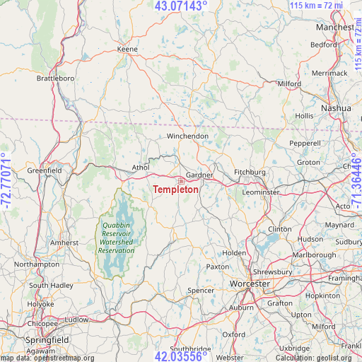
Templeton GPS coordinates[2]
42° 33' 20.304" North, 72° 4' 3.288" West
| Map corner | latitude | longitude |
|---|---|---|
| Upper-left | 43.07143°, | -72.77071° |
| Center: | 42.55564°, | -72.06758° |
| Lower-right: | 42.03556°, | -71.36446° |
| Map W x H: | 115.2×115.2 km | = 71.6×71.6mi |
| max Lat: | 71.29058° ⇑19.8% North |
| Templeton: | 42.55564° |
| min Lat: | ⇓80.2% South 19.06759° |
| min Long | Templeton | max Long |
| -171.73463° | -72.06758° | -66.98998° |
| W 95.6%⇐ | ⇒4.4% E |
Elevation
Elevation of Templeton is 349 m = 1145 ft, and this is 54.2 m = 178 ft above average elevation for this country.
| Max E: |
3189 m = 10463 ft | 20.4% |
| Templeton | 349 m 1145 ft | |
| Avg. | 294.8 m = 967 ft | |
Min E: |
-60 m = -197 ft | 79.6% |
See also: United States elevation on elevation.city.
Geographical zone
Templeton is located in North temperate zone (between Tropic of Cancer and the Arctic Circle). Distance of this Northern Tropic circle is 2125.8 km =1320.9 mi to South.| Distance of | km | miles | from Templeton |
|---|---|---|---|
| North Pole | 5275.3 | 3277.9 | to North |
| Arctic Circle | 2669.4 | 1658.7 | to North |
| Tropic Cancer | 2125.8 | 1320.9 | to South |
| Equator | 4731.7 | 2940.1 | to South |


Nearby cities:
15 places around Templeton: (largest is in red/bold)
• Ashburnham
15.8 km =9.8 mi,  55°
55°
• Athol
13.8 km =8.6 mi,  288°
288°
• Baldwinville
5.9 km =3.7 mi,  353°
353°
• Barre
15.1 km =9.4 mi,  191°
191°
• Fitchburg
21.9 km =13.6 mi,  81°
81°
• Gardner
6.1 km =3.8 mi,  69°
69°
• Hubbardston
10.4 km =6.5 mi,  151°
151°
• Orange
20.2 km =12.6 mi,  281°
281°
• Phillipston
5.4 km =3.4 mi,  261°
261°
• Princeton
19.6 km =12.2 mi,  127°
127°
• Rindge
22.3 km =13.9 mi,  12°
12°
• Royalston
16.8 km =10.4 mi,  324°
324°
• South Ashburnham
12.2 km =7.6 mi, 59°
• Westminster
12.9 km =8 mi,  94°
94°
• Winchendon
14.6 km =9.1 mi, 7°
Sources, notices
• [Note1] Compared only with cities in United States existing in our database
• [Src1] Map data: © OpenStreetMap contributors (CC-BY-SA)
• [Src2] Other city data from geonames.org with taken over terms of usage.
• [Src3] Geographical zone / Annual Mean Temperature by Robert A. Rohde @ Wikipedia
