Waltham geodata
Waltham (Massachusetts) is a populated place; located in United States in America/New_York (GMT-4) time zone. With population of 63,378 people, there are 689 cities with bigger population in this country. Compared to other cities in United States, 78.8% of cities are located further ↓South; 97.1% of cities are located further ←West and 87.4% of cities have higher elevation than Waltham. Note1
Administrative division(s):
- Level 1: Massachusetts
- Level 2: Middlesex County
- Level 3: City of Waltham


Waltham GPS coordinates[2]
42° 22' 35.364" North, 71° 14' 8.196" West
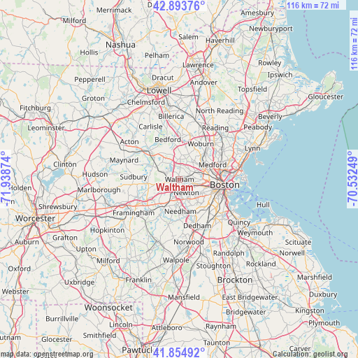
| Map corner | latitude | longitude |
|---|---|---|
| Upper-left | 42.89376°, | -71.93874° |
| Center: | 42.37649°, | -71.23561° |
| Lower-right: | 41.85492°, | -70.53249° |
| Map W x H: | 115.5×115.5 km | = 71.8×71.8mi |
| max Lat: | 71.29058° ⇑21.2% North |
| Waltham: | 42.37649° |
| min Lat: | ⇓78.8% South 19.06759° |
| min Long | Waltham | max Long |
| -171.73463° | -71.23561° | -66.98998° |
| W 97.1%⇐ | ⇒2.9% E |
Elevation
Elevation of Waltham is 22 m = 72 ft, and this is 272.8 m = 895 ft below average elevation for this country.
| Max E: |
3189 m = 10463 ft | 87.4% |
| Avg. | 294.8 m = 967 ft | |
| Waltham | 22 m = 72 ft | |
Min E: |
-60 m = -197 ft | 12.6% |
See also: Waltham elevation on elevation.city.
Geographical zone
Waltham is located in North temperate zone (between Tropic of Cancer and the Arctic Circle). Distance of this Northern Tropic circle is 2105.9 km =1308.5 mi to South.| Distance of | km | miles | from Waltham |
|---|---|---|---|
| North Pole | 5295.2 | 3290.3 | to North |
| Arctic Circle | 2689.4 | 1671.1 | to North |
| Tropic Cancer | 2105.9 | 1308.5 | to South |
| Equator | 4711.8 | 2927.8 | to South |


Nearby cities:
15 places around Waltham: (largest is in red/bold)
• Arlington
7.8 km =4.8 mi,  56°
56°
• Belmont
5.2 km =3.2 mi,  65°
65°
• Brookline
10.6 km =6.6 mi,  117°
117°
• Cambridge
10.7 km =6.6 mi,  90°
90°
• Lexington
7.9 km =4.9 mi,  6°
6°
• Lincoln
7.9 km =4.9 mi,  314°
314°
• Medford
11.6 km =7.2 mi, 66°
• Needham
10.3 km =6.4 mi,  178°
178°
• Newton
4.9 km =3 mi,  153°
153°
• Somerville
11.2 km =7 mi,  83°
83°
• Watertown
4.4 km =2.7 mi,  98°
98°
• Wayland
10.5 km =6.5 mi,  261°
261°
• Wellesley
10.1 km =6.3 mi,  207°
207°
• Weston
5.6 km =3.5 mi, 258°
• Winchester
11.7 km =7.3 mi,  43°
43°
Sources, notices
• [Note1] Compared only with cities in United States existing in our database
• [Src1] Map data: © OpenStreetMap contributors (CC-BY-SA)
• [Src2] Other city data from geonames.org with taken over terms of usage.
• [Src3] Geographical zone / Annual Mean Temperature by Robert A. Rohde @ Wikipedia
