Needham geodata
Needham (Massachusetts) is a populated place; located in United States in America/New_York (GMT-4) time zone. With population of 28,886 people, there are 1728 cities with bigger population in this country. Compared to other cities in United States, 78.1% of cities are located further ↓South; 97.1% of cities are located further ←West and 77.5% of cities have higher elevation than Needham. Note1


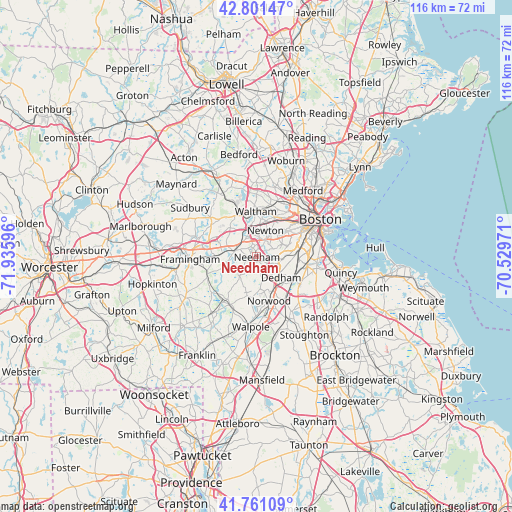
Needham GPS coordinates[2]
42° 17' 0.348" North, 71° 13' 58.188" West
| Map corner | latitude | longitude |
|---|---|---|
| Upper-left | 42.80147°, | -71.93596° |
| Center: | 42.28343°, | -71.23283° |
| Lower-right: | 41.76109°, | -70.52971° |
| Map W x H: | 115.7×115.7 km | = 71.9×71.9mi |
| max Lat: | 71.29058° ⇑21.9% North |
| Needham: | 42.28343° |
| min Lat: | ⇓78.1% South 19.06759° |
| min Long | Needham | max Long |
| -171.73463° | -71.23283° | -66.98998° |
| W 97.1%⇐ | ⇒2.9% E |
Elevation
Elevation of Needham is 58 m = 190 ft, and this is 236.8 m = 777 ft below average elevation for this country.
| Max E: |
3189 m = 10463 ft | 77.5% |
| Avg. | 294.8 m = 967 ft | |
| Needham | 58 m = 190 ft | |
Min E: |
-60 m = -197 ft | 22.5% |
See also: United States elevation on elevation.city.
Geographical zone
Needham is located in North temperate zone (between Tropic of Cancer and the Arctic Circle). Distance of this Northern Tropic circle is 2095.6 km =1302.1 mi to South.| Distance of | km | miles | from Needham |
|---|---|---|---|
| North Pole | 5305.6 | 3296.7 | to North |
| Arctic Circle | 2699.7 | 1677.5 | to North |
| Tropic Cancer | 2095.6 | 1302.1 | to South |
| Equator | 4701.5 | 2921.4 | to South |


Nearby cities:
15 places around Needham: (largest is in red/bold)
• Brookline
10.6 km =6.6 mi,  59°
59°
• Cochituate
11.6 km =7.2 mi,  291°
291°
• Dedham
7.2 km =4.5 mi,  130°
130°
• Dover
5.9 km =3.7 mi,  224°
224°
• Jamaica Plain
9.7 km =6 mi,  72°
72°
• Medfield
12.3 km =7.6 mi,  209°
209°
• Natick
9.6 km =6 mi,  270°
270°
• Newton
6.3 km =3.9 mi,  18°
18°
• Norwood
10.3 km =6.4 mi,  164°
164°
• Sherborn
12.3 km =7.6 mi,  246°
246°
• Waltham
10.3 km =6.4 mi,  358°
358°
• Watertown
10.6 km =6.6 mi, 22°
• Wellesley
5.1 km =3.2 mi, 286°
• Weston
10.9 km =6.8 mi,  328°
328°
• Westwood
7.8 km =4.8 mi,  174°
174°
Sources, notices
• [Note1] Compared only with cities in United States existing in our database
• [Src1] Map data: © OpenStreetMap contributors (CC-BY-SA)
• [Src2] Other city data from geonames.org with taken over terms of usage.
• [Src3] Geographical zone / Annual Mean Temperature by Robert A. Rohde @ Wikipedia
