Medford geodata
Medford (Massachusetts) is a populated place; located in United States in America/New_York (GMT-4) time zone. With population of 57,403 people, there are 791 cities with bigger population in this country. Compared to other cities in United States, 79.1% of cities are located further ↓South; 97.4% of cities are located further ←West and 92.1% of cities have higher elevation than Medford. Note1
Administrative division(s):
- Level 1: Massachusetts
- Level 2: Middlesex County
- Level 3: City of Medford


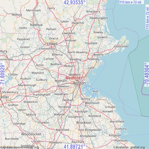
Medford GPS coordinates[2]
42° 25' 6.348" North, 71° 6' 22.176" West
| Map corner | latitude | longitude |
|---|---|---|
| Upper-left | 42.93535°, | -71.80929° |
| Center: | 42.41843°, | -71.10616° |
| Lower-right: | 41.89721°, | -70.40304° |
| Map W x H: | 115.4×115.4 km | = 71.7×71.7mi |
| max Lat: | 71.29058° ⇑20.9% North |
| Medford: | 42.41843° |
| min Lat: | ⇓79.1% South 19.06759° |
| min Long | Medford | max Long |
| -171.73463° | -71.10616° | -66.98998° |
| W 97.4%⇐ | ⇒2.6% E |
Elevation
Elevation of Medford is 12 m = 39 ft, and this is 282.8 m = 928 ft below average elevation for this country.
| Max E: |
3189 m = 10463 ft | 92.1% |
| Avg. | 294.8 m = 967 ft | |
| Medford | 12 m = 39 ft | |
Min E: |
-60 m = -197 ft | 7.9% |
See also: Medford elevation on elevation.city.
Geographical zone
Medford is located in North temperate zone (between Tropic of Cancer and the Arctic Circle). Distance of this Northern Tropic circle is 2110.6 km =1311.5 mi to South.| Distance of | km | miles | from Medford |
|---|---|---|---|
| North Pole | 5290.6 | 3287.4 | to North |
| Arctic Circle | 2684.7 | 1668.2 | to North |
| Tropic Cancer | 2110.6 | 1311.5 | to South |
| Equator | 4716.5 | 2930.7 | to South |


Nearby cities:
15 places around Medford: (largest is in red/bold)
• Arlington
4.1 km =2.5 mi,  265°
265°
• Belmont
6.5 km =4 mi,  247°
247°
• Boston
7.7 km =4.8 mi,  150°
150°
• Cambridge
4.8 km =3 mi,  179°
179°
• Chelsea
6.7 km =4.2 mi,  116°
116°
• Everett
4.5 km =2.8 mi,  104°
104°
• Malden
3.4 km =2.1 mi,  77°
77°
• Melrose
5.5 km =3.4 mi,  36°
36°
• Revere
7.8 km =4.8 mi, 98°
• Saugus
9.4 km =5.8 mi,  56°
56°
• Somerville
3.5 km =2.2 mi,  170°
170°
• Stoneham
6.9 km =4.3 mi,  4°
4°
• Watertown
8.2 km =5.1 mi,  230°
230°
• Winchester
4.5 km =2.8 mi,  326°
326°
• Woburn
7.8 km =4.8 mi, 330°
Sources, notices
• [Note1] Compared only with cities in United States existing in our database
• [Src1] Map data: © OpenStreetMap contributors (CC-BY-SA)
• [Src2] Other city data from geonames.org with taken over terms of usage.
• [Src3] Geographical zone / Annual Mean Temperature by Robert A. Rohde @ Wikipedia
