Weymouth geodata
Weymouth (Massachusetts) is a populated place; located in United States in America/New_York (GMT-4) time zone. With population of 54,395 people, there are 853 cities with bigger population in this country. Compared to other cities in United States, 77.5% of cities are located further ↓South; 97.7% of cities are located further ←West and 81.8% of cities have higher elevation than Weymouth. Note1
Administrative division(s):
- Level 1: Massachusetts
- Level 2: Norfolk County
- Level 3: City of Weymouth Town


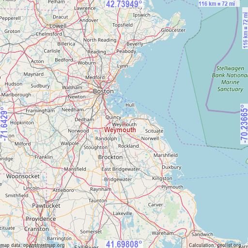
Weymouth GPS coordinates[2]
42° 13' 15.348" North, 70° 56' 23.172" West
| Map corner | latitude | longitude |
|---|---|---|
| Upper-left | 42.73949°, | -71.6429° |
| Center: | 42.22093°, | -70.93977° |
| Lower-right: | 41.69808°, | -70.23665° |
| Map W x H: | 115.8×115.8 km | = 72×72mi |
| max Lat: | 71.29058° ⇑22.5% North |
| Weymouth: | 42.22093° |
| min Lat: | ⇓77.5% South 19.06759° |
| min Long | Weymouth | max Long |
| -171.73463° | -70.93977° | -66.98998° |
| W 97.7%⇐ | ⇒2.3% E |
Elevation
Elevation of Weymouth is 39 m = 128 ft, and this is 255.8 m = 839 ft below average elevation for this country.
| Max E: |
3189 m = 10463 ft | 81.8% |
| Avg. | 294.8 m = 967 ft | |
| Weymouth | 39 m = 128 ft | |
Min E: |
-60 m = -197 ft | 18.2% |
See also: Weymouth elevation on elevation.city.
Geographical zone
Weymouth is located in North temperate zone (between Tropic of Cancer and the Arctic Circle). Distance of this Northern Tropic circle is 2088.6 km =1297.8 mi to South.| Distance of | km | miles | from Weymouth |
|---|---|---|---|
| North Pole | 5312.5 | 3301 | to North |
| Arctic Circle | 2706.6 | 1681.8 | to North |
| Tropic Cancer | 2088.6 | 1297.8 | to South |
| Equator | 4694.5 | 2917 | to South |


Nearby cities:
15 places around Weymouth: (largest is in red/bold)
• Abington
12.9 km =8 mi,  182°
182°
• Avon
13.1 km =8.1 mi,  219°
219°
• Braintree
5.5 km =3.4 mi,  249°
249°
• Cohasset
11.4 km =7.1 mi,  78°
78°
• Hingham
4.7 km =2.9 mi,  60°
60°
• Holbrook
9.3 km =5.8 mi, 217°
• Hull
9.4 km =5.8 mi,  16°
16°
• Milton
10.9 km =6.8 mi,  287°
287°
• North Scituate
12.7 km =7.9 mi,  90°
90°
• Norwell
13.7 km =8.5 mi,  118°
118°
• Quincy
6.3 km =3.9 mi,  304°
304°
• Randolph
10.6 km =6.6 mi,  232°
232°
• Rockland
10.2 km =6.3 mi,  169°
169°
• South Boston
15.4 km =9.6 mi,  324°
324°
• Whitman
15.6 km =9.7 mi, 178°
Sources, notices
• [Note1] Compared only with cities in United States existing in our database
• [Src1] Map data: © OpenStreetMap contributors (CC-BY-SA)
• [Src2] Other city data from geonames.org with taken over terms of usage.
• [Src3] Geographical zone / Annual Mean Temperature by Robert A. Rohde @ Wikipedia
