Milton geodata
Milton (Massachusetts) is a populated place; located in United States in America/New_York (GMT-4) time zone. With population of 27,003 people, there are 1853 cities with bigger population in this country. Compared to other cities in United States, 77.8% of cities are located further ↓South; 97.5% of cities are located further ←West and 80.9% of cities have higher elevation than Milton. Note1


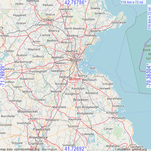
Milton GPS coordinates[2]
42° 14' 58.344" North, 71° 3' 58.176" West
| Map corner | latitude | longitude |
|---|---|---|
| Upper-left | 42.76786°, | -71.76929° |
| Center: | 42.24954°, | -71.06616° |
| Lower-right: | 41.72692°, | -70.36304° |
| Map W x H: | 115.7×115.7 km | = 71.9×71.9mi |
| max Lat: | 71.29058° ⇑22.2% North |
| Milton: | 42.24954° |
| min Lat: | ⇓77.8% South 19.06759° |
| min Long | Milton | max Long |
| -171.73463° | -71.06616° | -66.98998° |
| W 97.5%⇐ | ⇒2.5% E |
Elevation
Elevation of Milton is 43 m = 141 ft, and this is 251.8 m = 826 ft below average elevation for this country.
| Max E: |
3189 m = 10463 ft | 80.9% |
| Avg. | 294.8 m = 967 ft | |
| Milton | 43 m = 141 ft | |
Min E: |
-60 m = -197 ft | 19.1% |
See also: United States elevation on elevation.city.
Geographical zone
Milton is located in North temperate zone (between Tropic of Cancer and the Arctic Circle). Distance of this Northern Tropic circle is 2091.8 km =1299.8 mi to South.| Distance of | km | miles | from Milton |
|---|---|---|---|
| North Pole | 5309.4 | 3299.1 | to North |
| Arctic Circle | 2703.5 | 1679.9 | to North |
| Tropic Cancer | 2091.8 | 1299.8 | to South |
| Equator | 4697.7 | 2919 | to South |


Nearby cities:
15 places around Milton: (largest is in red/bold)
• Avon
13.4 km =8.3 mi,  171°
171°
• Boston
12.1 km =7.5 mi,  2°
2°
• Braintree
7.3 km =4.5 mi,  133°
133°
• Brookline
10.2 km =6.3 mi,  333°
333°
• Canton
12 km =7.5 mi,  212°
212°
• Dedham
8.3 km =5.2 mi,  264°
264°
• Holbrook
11.5 km =7.1 mi,  155°
155°
• Jamaica Plain
8 km =5 mi, 326°
• Norwood
12.6 km =7.8 mi,  240°
240°
• Quincy
5.3 km =3.3 mi,  85°
85°
• Randolph
9.9 km =6.2 mi, 167°
• South Boston
9.4 km =5.8 mi,  8°
8°
• Stoughton
14.2 km =8.8 mi,  192°
192°
• Westwood
13.6 km =8.5 mi,  253°
253°
• Weymouth
10.9 km =6.8 mi,  107°
107°
Sources, notices
• [Note1] Compared only with cities in United States existing in our database
• [Src1] Map data: © OpenStreetMap contributors (CC-BY-SA)
• [Src2] Other city data from geonames.org with taken over terms of usage.
• [Src3] Geographical zone / Annual Mean Temperature by Robert A. Rohde @ Wikipedia
