Quincy geodata
Quincy (Massachusetts) is a populated place; located in United States in America/New_York (GMT-4) time zone. With population of 93,618 people, there are 388 cities with bigger population in this country. Compared to other cities in United States, 77.8% of cities are located further ↓South; 97.6% of cities are located further ←West and 89.5% of cities have higher elevation than Quincy. Note1


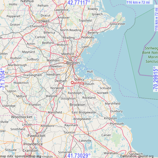
Quincy GPS coordinates[2]
42° 15' 10.368" North, 71° 0' 8.172" West
| Map corner | latitude | longitude |
|---|---|---|
| Upper-left | 42.77117°, | -71.7054° |
| Center: | 42.25288°, | -71.00227° |
| Lower-right: | 41.73029°, | -70.29915° |
| Map W x H: | 115.7×115.7 km | = 71.9×71.9mi |
| max Lat: | 71.29058° ⇑22.2% North |
| Quincy: | 42.25288° |
| min Lat: | ⇓77.8% South 19.06759° |
| min Long | Quincy | max Long |
| -171.73463° | -71.00227° | -66.98998° |
| W 97.6%⇐ | ⇒2.4% E |
Elevation
Elevation of Quincy is 17 m = 56 ft, and this is 277.8 m = 911 ft below average elevation for this country.
| Max E: |
3189 m = 10463 ft | 89.5% |
| Avg. | 294.8 m = 967 ft | |
| Quincy | 17 m = 56 ft | |
Min E: |
-60 m = -197 ft | 10.5% |
See also: Quincy elevation on elevation.city.
Geographical zone
Quincy is located in North temperate zone (between Tropic of Cancer and the Arctic Circle). Distance of this Northern Tropic circle is 2092.2 km =1300 mi to South.| Distance of | km | miles | from Quincy |
|---|---|---|---|
| North Pole | 5309 | 3298.9 | to North |
| Arctic Circle | 2703.1 | 1679.6 | to North |
| Tropic Cancer | 2092.2 | 1300 | to South |
| Equator | 4698.1 | 2919.3 | to South |


Nearby cities:
15 places around Quincy: (largest is in red/bold)
• Avon
14 km =8.7 mi,  193°
193°
• Boston
12.7 km =7.9 mi,  338°
338°
• Braintree
5.5 km =3.4 mi,  179°
179°
• Brookline
13.1 km =8.1 mi,  311°
311°
• Dedham
13.5 km =8.4 mi,  264°
264°
• Hingham
9.3 km =5.8 mi,  97°
97°
• Holbrook
10.9 km =6.8 mi, 182°
• Hull
9.5 km =5.9 mi,  54°
54°
• Jamaica Plain
11.6 km =7.2 mi,  303°
303°
• Milton
5.3 km =3.3 mi,  265°
265°
• Randolph
10.5 km =6.5 mi,  197°
197°
• Rockland
15.3 km =9.5 mi,  152°
152°
• South Boston
9.8 km =6.1 mi, 336°
• Weymouth
6.3 km =3.9 mi,  124°
124°
• Winthrop
13.7 km =8.5 mi,  6°
6°
Sources, notices
• [Note1] Compared only with cities in United States existing in our database
• [Src1] Map data: © OpenStreetMap contributors (CC-BY-SA)
• [Src2] Other city data from geonames.org with taken over terms of usage.
• [Src3] Geographical zone / Annual Mean Temperature by Robert A. Rohde @ Wikipedia
