Bangor geodata
Bangor (Maine) is a seat of a second-order administrative division; located in United States in America/New_York (GMT-4) time zone. With population of 32,391 people, there are 1539 cities with bigger population in this country. Compared to other cities in United States, 91.7% of cities are located further ↓South; 99.6% of cities are located further ←West and 83.6% of cities have higher elevation than Bangor. Note1


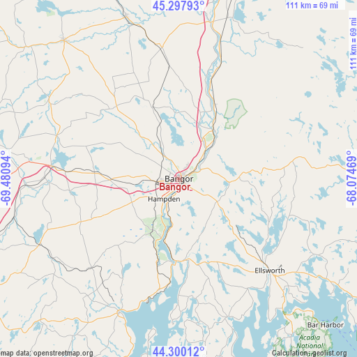
Bangor GPS coordinates[2]
44° 48' 4.248" North, 68° 46' 40.116" West
| Map corner | latitude | longitude |
|---|---|---|
| Upper-left | 45.29793°, | -69.48094° |
| Center: | 44.80118°, | -68.77781° |
| Lower-right: | 44.30012°, | -68.07469° |
| Map W x H: | 110.9×110.9 km | = 68.9×68.9mi |
| max Lat: | 71.29058° ⇑8.3% North |
| Bangor: | 44.80118° |
| min Lat: | ⇓91.7% South 19.06759° |
| min Long | Bangor | max Long |
| -171.73463° | -68.77781° | -66.98998° |
| W 99.6%⇐ | ⇒0.40000000000001% E |
Elevation
Elevation of Bangor is 33 m = 108 ft, and this is 261.8 m = 859 ft below average elevation for this country.
| Max E: |
3189 m = 10463 ft | 83.6% |
| Avg. | 294.8 m = 967 ft | |
| Bangor | 33 m = 108 ft | |
Min E: |
-60 m = -197 ft | 16.4% |
See also: United States elevation on elevation.city.
Geographical zone
Bangor is located in North temperate zone (between Tropic of Cancer and the Arctic Circle). Distance of this Northern Tropic circle is 2375.5 km =1476.1 mi to South.| Distance of | km | miles | from Bangor |
|---|---|---|---|
| North Pole | 5025.6 | 3122.8 | to North |
| Arctic Circle | 2419.7 | 1503.5 | to North |
| Tropic Cancer | 2375.5 | 1476.1 | to South |
| Equator | 4981.4 | 3095.3 | to South |


Nearby cities:
15 places around Bangor: (largest is in red/bold)
• Bradley
17.8 km =11.1 mi,  41°
41°
• Brewer
1.4 km =0.9 mi,  110°
110°
• Dedham
15.2 km =9.4 mi,  143°
143°
• Eddington
7.2 km =4.5 mi,  67°
67°
• Hampden
7.8 km =4.8 mi,  216°
216°
• Hermon
10.7 km =6.6 mi,  275°
275°
• Holden
9.5 km =5.9 mi,  124°
124°
• Kenduskeag
17.9 km =11.1 mi,  317°
317°
• Levant
14.5 km =9 mi,  301°
301°
• Milford
19.3 km =12 mi,  33°
33°
• Old Town
18.1 km =11.2 mi, 35°
• Orono
12.4 km =7.7 mi, 42°
• Orrington
8.7 km =5.4 mi,  206°
206°
• Veazie
7.1 km =4.4 mi,  53°
53°
• Winterport
18.9 km =11.7 mi,  196°
196°
Sources, notices
• [Note1] Compared only with cities in United States existing in our database
• [Src1] Map data: © OpenStreetMap contributors (CC-BY-SA)
• [Src2] Other city data from geonames.org with taken over terms of usage.
• [Src3] Geographical zone / Annual Mean Temperature by Robert A. Rohde @ Wikipedia
