Old Orchard Beach geodata
Old Orchard Beach (Maine) is a populated place; located in United States in America/New_York (GMT-4) time zone. With population of 8,624 people, there are 4961 cities with bigger population in this country. Compared to other cities in United States, 86.4% of cities are located further ↓South; 98.5% of cities are located further ←West and 90.5% of cities have higher elevation than Old Orchard Beach. Note1


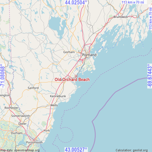
Old Orchard Beach GPS coordinates[2]
43° 31' 2.316" North, 70° 22' 39.18" West
| Map corner | latitude | longitude |
|---|---|---|
| Upper-left | 44.02504°, | -71.08068° |
| Center: | 43.51731°, | -70.37755° |
| Lower-right: | 43.00527°, | -69.67443° |
| Map W x H: | 113.4×113.4 km | = 70.5×70.5mi |
| max Lat: | 71.29058° ⇑13.6% North |
| Old Orchard Beach: | 43.51731° |
| min Lat: | ⇓86.4% South 19.06759° |
| min Long | Old Orchard Bea | max Long |
| -171.73463° | -70.37755° | -66.98998° |
| W 98.5%⇐ | ⇒1.5% E |
Elevation
Elevation of Old Orchard Beach is 15 m = 49 ft, and this is 279.8 m = 918 ft below average elevation for this country.
| Max E: |
3189 m = 10463 ft | 90.5% |
| Avg. | 294.8 m = 967 ft | |
| Old Orchard Beach | 15 m = 49 ft | |
Min E: |
-60 m = -197 ft | 9.5% |
See also: United States elevation on elevation.city.
Geographical zone
Old Orchard Beach is located in North temperate zone (between Tropic of Cancer and the Arctic Circle). Distance of this Northern Tropic circle is 2232.8 km =1387.4 mi to South.| Distance of | km | miles | from Old Orchard Beach |
|---|---|---|---|
| North Pole | 5168.4 | 3211.5 | to North |
| Arctic Circle | 2562.5 | 1592.3 | to North |
| Tropic Cancer | 2232.8 | 1387.4 | to South |
| Equator | 4838.7 | 3006.6 | to South |


Nearby cities:
15 places around Old Orchard Beach: (largest is in red/bold)
• Arundel
17 km =10.6 mi,  208°
208°
• Biddeford
6.7 km =4.2 mi,  245°
245°
• Buxton
17.6 km =10.9 mi,  319°
319°
• Dayton
16.4 km =10.2 mi,  282°
282°
• Gorham
18.8 km =11.7 mi,  343°
343°
• Hollis Center
19.9 km =12.4 mi,  299°
299°
• Kennebunk
20.1 km =12.5 mi,  222°
222°
• Kennebunkport
19.1 km =11.9 mi,  204°
204°
• Portland
18.3 km =11.4 mi,  31°
31°
• Saco
5.6 km =3.5 mi, 250°
• Scarborough
8.1 km =5 mi, 33°
• South Portland
17.7 km =11 mi,  38°
38°
• South Portland Gardens
14.4 km =8.9 mi,  20°
20°
• West Scarborough
6 km =3.7 mi,  352°
352°
• Westbrook
17.8 km =11.1 mi,  1°
1°
Sources, notices
• [Note1] Compared only with cities in United States existing in our database
• [Src1] Map data: © OpenStreetMap contributors (CC-BY-SA)
• [Src2] Other city data from geonames.org with taken over terms of usage.
• [Src3] Geographical zone / Annual Mean Temperature by Robert A. Rohde @ Wikipedia
