Portland geodata
Portland (Maine) is a seat of a second-order administrative division; located in United States in America/New_York (GMT-4) time zone. With population of 66,881 people, there are 633 cities with bigger population in this country. Compared to other cities in United States, 87% of cities are located further ↓South; 98.6% of cities are located further ←West and 93.9% of cities have higher elevation than Portland. Note1


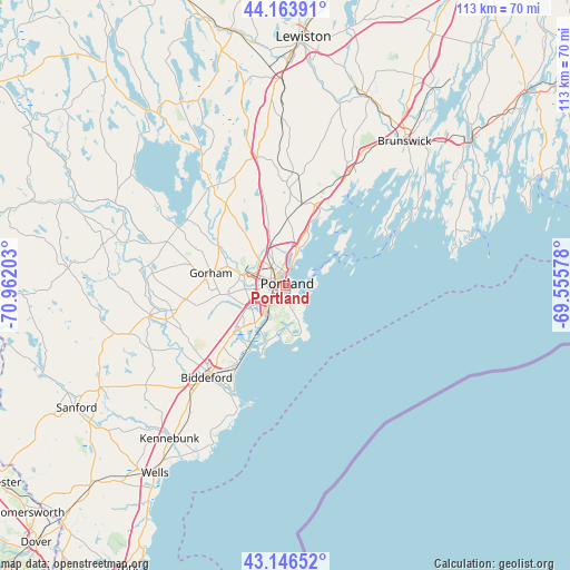
Portland GPS coordinates[2]
43° 39' 26.532" North, 70° 15' 32.04" West
| Map corner | latitude | longitude |
|---|---|---|
| Upper-left | 44.16391°, | -70.96203° |
| Center: | 43.65737°, | -70.2589° |
| Lower-right: | 43.14652°, | -69.55578° |
| Map W x H: | 113.1×113.1 km | = 70.3×70.3mi |
| max Lat: | 71.29058° ⇑13% North |
| Portland: | 43.65737° |
| min Lat: | ⇓87% South 19.06759° |
| min Long | Portland | max Long |
| -171.73463° | -70.2589° | -66.98998° |
| W 98.6%⇐ | ⇒1.4% E |
Elevation
Elevation of Portland is 10 m = 33 ft, and this is 284.8 m = 934 ft below average elevation for this country.
| Max E: |
3189 m = 10463 ft | 93.9% |
| Avg. | 294.8 m = 967 ft | |
| Portland | 10 m = 33 ft | |
Min E: |
-60 m = -197 ft | 6.1% |
See also: Portland elevation on elevation.city.
Geographical zone
Portland is located in North temperate zone (between Tropic of Cancer and the Arctic Circle). Distance of this Northern Tropic circle is 2248.3 km =1397 mi to South.| Distance of | km | miles | from Portland |
|---|---|---|---|
| North Pole | 5152.8 | 3201.8 | to North |
| Arctic Circle | 2546.9 | 1582.6 | to North |
| Tropic Cancer | 2248.3 | 1397 | to South |
| Equator | 4854.2 | 3016.3 | to South |


Nearby cities:
15 places around Portland: (largest is in red/bold)
• Buxton
21 km =13 mi,  264°
264°
• Cumberland Center
15.5 km =9.6 mi,  359°
359°
• Falmouth
8.1 km =5 mi,  9°
9°
• Falmouth Foreside
9.5 km =5.9 mi,  25°
25°
• Gorham
15.1 km =9.4 mi,  279°
279°
• Little Falls
15.9 km =9.9 mi,  301°
301°
• Old Orchard Beach
18.3 km =11.4 mi,  211°
211°
• Saco
22.8 km =14.2 mi,  220°
220°
• Scarborough
10.2 km =6.3 mi, 209°
• South Portland
2.3 km =1.4 mi,  140°
140°
• South Portland Gardens
5 km =3.1 mi,  245°
245°
• South Windham
15.9 km =9.9 mi, 303°
• West Scarborough
14.2 km =8.8 mi,  227°
227°
• Westbrook
9.3 km =5.8 mi, 283°
• Yarmouth
17 km =10.6 mi,  20°
20°
Sources, notices
• [Note1] Compared only with cities in United States existing in our database
• [Src1] Map data: © OpenStreetMap contributors (CC-BY-SA)
• [Src2] Other city data from geonames.org with taken over terms of usage.
• [Src3] Geographical zone / Annual Mean Temperature by Robert A. Rohde @ Wikipedia
