Albion geodata
Albion (Michigan) is a populated place; located in United States in America/Detroit (GMT-4) time zone. With population of 8,229 people, there are 5175 cities with bigger population in this country. Compared to other cities in United States, 77.7% of cities are located further ↓South; 56.5% of cities are located further ←West and 71.5% of cities have lower elevation than Albion. Note1


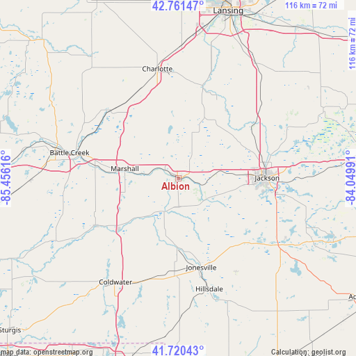
Albion GPS coordinates[2]
42° 14' 35.16" North, 84° 45' 10.908" West
| Map corner | latitude | longitude |
|---|---|---|
| Upper-left | 42.76147°, | -85.45616° |
| Center: | 42.2431°, | -84.75303° |
| Lower-right: | 41.72043°, | -84.04991° |
| Map W x H: | 115.8×115.8 km | = 72×72mi |
| max Lat: | 71.29058° ⇑22.3% North |
| Albion: | 42.2431° |
| min Lat: | ⇓77.7% South 19.06759° |
| min Long | Albion | max Long |
| -171.73463° | -84.75303° | -66.98998° |
| W 56.5%⇐ | ⇒43.5% E |
Elevation
Elevation of Albion is 293 m = 961 ft, and this is 1.8 m = 6 ft below average elevation for this country.
| Max E: |
3189 m = 10463 ft | 28.5% |
| Avg. | 294.8 m = 967 ft | |
| Albion | 293 m = 961 ft | |
Min E: |
-60 m = -197 ft | 71.5% |
See also: United States elevation on elevation.city.
Geographical zone
Albion is located in North temperate zone (between Tropic of Cancer and the Arctic Circle). Distance of this Northern Tropic circle is 2091.1 km =1299.3 mi to South.| Distance of | km | miles | from Albion |
|---|---|---|---|
| North Pole | 5310.1 | 3299.5 | to North |
| Arctic Circle | 2704.2 | 1680.3 | to North |
| Tropic Cancer | 2091.1 | 1299.3 | to South |
| Equator | 4697 | 2918.6 | to South |


Nearby cities:
15 places around Albion: (largest is in red/bold)
• Bellevue
31.1 km =19.3 mi,  315°
315°
• Brownlee Park
33.1 km =20.6 mi,  284°
284°
• Concord
11.6 km =7.2 mi,  128°
128°
• Eaton Rapids
30.6 km =19 mi,  15°
15°
• Homer
11.7 km =7.3 mi,  203°
203°
• Jackson
28.9 km =18 mi,  89°
89°
• Jonesville
29.8 km =18.5 mi,  165°
165°
• Litchfield
22.1 km =13.7 mi,  180°
180°
• Marshall
17.6 km =10.9 mi, 280°
• Olivet
26.2 km =16.3 mi,  327°
327°
• Parma
12.7 km =7.9 mi,  82°
82°
• Spring Arbor
17 km =10.6 mi,  104°
104°
• Springport
15.7 km =9.8 mi, 16°
• Tekonsha
25.4 km =15.8 mi,  229°
229°
• Vandercook Lake
30.3 km =18.8 mi, 100°
Sources, notices
• [Note1] Compared only with cities in United States existing in our database
• [Src1] Map data: © OpenStreetMap contributors (CC-BY-SA)
• [Src2] Other city data from geonames.org with taken over terms of usage.
• [Src3] Geographical zone / Annual Mean Temperature by Robert A. Rohde @ Wikipedia
