Marshall geodata
Marshall (Michigan) is a seat of a second-order administrative division; located in United States in America/Detroit (GMT-4) time zone. With population of 7,045 people, there are 5788 cities with bigger population in this country. Compared to other cities in United States, 78% of cities are located further ↓South; 55.9% of cities are located further ←West and 69% of cities have lower elevation than Marshall. Note1


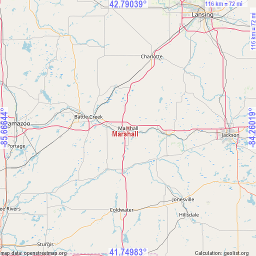
Marshall GPS coordinates[2]
42° 16' 20.136" North, 84° 57' 47.916" West
| Map corner | latitude | longitude |
|---|---|---|
| Upper-left | 42.79039°, | -85.66644° |
| Center: | 42.27226°, | -84.96331° |
| Lower-right: | 41.74983°, | -84.26019° |
| Map W x H: | 115.7×115.7 km | = 71.9×71.9mi |
| max Lat: | 71.29058° ⇑22% North |
| Marshall: | 42.27226° |
| min Lat: | ⇓78% South 19.06759° |
| min Long | Marshall | max Long |
| -171.73463° | -84.96331° | -66.98998° |
| W 55.9%⇐ | ⇒44.1% E |
Elevation
Elevation of Marshall is 281 m = 922 ft, and this is 13.8 m = 45 ft below average elevation for this country.
| Max E: |
3189 m = 10463 ft | 31% |
| Avg. | 294.8 m = 967 ft | |
| Marshall | 281 m = 922 ft | |
Min E: |
-60 m = -197 ft | 69% |
See also: United States elevation on elevation.city.
Geographical zone
Marshall is located in North temperate zone (between Tropic of Cancer and the Arctic Circle). Distance of this Northern Tropic circle is 2094.3 km =1301.3 mi to South.| Distance of | km | miles | from Marshall |
|---|---|---|---|
| North Pole | 5306.8 | 3297.5 | to North |
| Arctic Circle | 2700.9 | 1678.3 | to North |
| Tropic Cancer | 2094.3 | 1301.3 | to South |
| Equator | 4700.2 | 2920.6 | to South |


Nearby cities:
15 places around Marshall: (largest is in red/bold)
• Albion
17.6 km =10.9 mi,  100°
100°
• Athens
30.3 km =18.8 mi,  227°
227°
• Battle Creek
18.4 km =11.4 mi,  285°
285°
• Bellevue
19.6 km =12.2 mi,  346°
346°
• Brownlee Park
15.6 km =9.7 mi, 289°
• Concord
28.4 km =17.6 mi,  111°
111°
• Homer
19 km =11.8 mi,  137°
137°
• Lakeview
20.6 km =12.8 mi,  278°
278°
• Level Park-Oak Park
26.9 km =16.7 mi, 292°
• Olivet
19.1 km =11.9 mi,  9°
9°
• Parma
30 km =18.6 mi,  92°
92°
• Springfield
23.5 km =14.6 mi, 284°
• Springport
24.8 km =15.4 mi,  61°
61°
• Tekonsha
20 km =12.4 mi,  185°
185°
• Union City
26.9 km =16.7 mi,  211°
211°
Sources, notices
• [Note1] Compared only with cities in United States existing in our database
• [Src1] Map data: © OpenStreetMap contributors (CC-BY-SA)
• [Src2] Other city data from geonames.org with taken over terms of usage.
• [Src3] Geographical zone / Annual Mean Temperature by Robert A. Rohde @ Wikipedia
