Brownlee Park geodata
Brownlee Park (Michigan) is a populated place; located in United States in America/Detroit (GMT-4) time zone. With population of 2,108 people, there are 11590 cities with bigger population in this country. Compared to other cities in United States, 78.3% of cities are located further ↓South; 55.5% of cities are located further ←West and 66.7% of cities have lower elevation than Brownlee Park. Note1
Administrative division(s):
- Level 1: Michigan
- Level 2: Calhoun County
- Level 3: Charter Township of Emmett


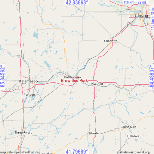
Brownlee Park GPS coordinates[2]
42° 19' 8.148" North, 85° 8' 32.964" West
| Map corner | latitude | longitude |
|---|---|---|
| Upper-left | 42.83668°, | -85.84562° |
| Center: | 42.31893°, | -85.14249° |
| Lower-right: | 41.79689°, | -84.43937° |
| Map W x H: | 115.6×115.6 km | = 71.8×71.8mi |
| max Lat: | 71.29058° ⇑21.7% North |
| Brownlee Park: | 42.31893° |
| min Lat: | ⇓78.3% South 19.06759° |
| min Long | Brownlee Park | max Long |
| -171.73463° | -85.14249° | -66.98998° |
| W 55.5%⇐ | ⇒44.5% E |
Elevation
Elevation of Brownlee Park is 270 m = 886 ft, and this is 24.8 m = 81 ft below average elevation for this country.
| Max E: |
3189 m = 10463 ft | 33.3% |
| Avg. | 294.8 m = 967 ft | |
| Brownlee Park | 270 m = 886 ft | |
Min E: |
-60 m = -197 ft | 66.7% |
See also: United States elevation on elevation.city.
Geographical zone
Brownlee Park is located in North temperate zone (between Tropic of Cancer and the Arctic Circle). Distance of this Northern Tropic circle is 2099.5 km =1304.6 mi to South.| Distance of | km | miles | from Brownlee Park |
|---|---|---|---|
| North Pole | 5301.6 | 3294.3 | to North |
| Arctic Circle | 2695.8 | 1675.1 | to North |
| Tropic Cancer | 2099.5 | 1304.6 | to South |
| Equator | 4705.4 | 2923.8 | to South |


Nearby cities:
15 places around Brownlee Park: (largest is in red/bold)
• Athens
26.7 km =16.6 mi,  196°
196°
• Augusta
17.3 km =10.7 mi,  276°
276°
• Battle Creek
2.9 km =1.8 mi,  266°
266°
• Bellevue
17.2 km =10.7 mi,  36°
36°
• Climax
18.2 km =11.3 mi,  240°
240°
• Galesburg
22.9 km =14.2 mi,  261°
261°
• Lakeview
6.1 km =3.8 mi,  247°
247°
• Level Park-Oak Park
11.4 km =7.1 mi,  296°
296°
• Marshall
15.6 km =9.7 mi,  109°
109°
• Olivet
22.5 km =14 mi,  52°
52°
• Richland
26.5 km =16.5 mi, 283°
• South Gull Lake
22.2 km =13.8 mi,  290°
290°
• Springfield
8 km =5 mi, 275°
• Tekonsha
28.2 km =17.5 mi,  152°
152°
• Union City
28 km =17.4 mi,  178°
178°
Sources, notices
• [Note1] Compared only with cities in United States existing in our database
• [Src1] Map data: © OpenStreetMap contributors (CC-BY-SA)
• [Src2] Other city data from geonames.org with taken over terms of usage.
• [Src3] Geographical zone / Annual Mean Temperature by Robert A. Rohde @ Wikipedia
