Baroda geodata
Baroda (Michigan) is a populated place; located in United States in America/Detroit (GMT-4) time zone. With population of 850 people, there are 17359 cities with bigger population in this country. Compared to other cities in United States, 75.3% of cities are located further ↓South; 51.6% of cities are located further ←West and 51.1% of cities have higher elevation than Baroda. Note1


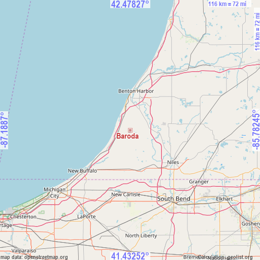
Baroda GPS coordinates[2]
41° 57' 27.144" North, 86° 29' 8.052" West
| Map corner | latitude | longitude |
|---|---|---|
| Upper-left | 42.47827°, | -87.1887° |
| Center: | 41.95754°, | -86.48557° |
| Lower-right: | 41.43252°, | -85.78245° |
| Map W x H: | 116.3×116.3 km | = 72.3×72.3mi |
| max Lat: | 71.29058° ⇑24.7% North |
| Baroda: | 41.95754° |
| min Lat: | ⇓75.3% South 19.06759° |
| min Long | Baroda | max Long |
| -171.73463° | -86.48557° | -66.98998° |
| W 51.6%⇐ | ⇒48.4% E |
Elevation
Elevation of Baroda is 194 m = 636 ft, and this is 100.8 m = 331 ft below average elevation for this country.
| Max E: |
3189 m = 10463 ft | 51.1% |
| Avg. | 294.8 m = 967 ft | |
| Baroda | 194 m = 636 ft | |
Min E: |
-60 m = -197 ft | 48.9% |
See also: United States elevation on elevation.city.
Geographical zone
Baroda is located in North temperate zone (between Tropic of Cancer and the Arctic Circle). Distance of this Northern Tropic circle is 2059.3 km =1279.6 mi to South.| Distance of | km | miles | from Baroda |
|---|---|---|---|
| North Pole | 5341.8 | 3319.2 | to North |
| Arctic Circle | 2735.9 | 1700 | to North |
| Tropic Cancer | 2059.3 | 1279.6 | to South |
| Equator | 4665.2 | 2898.8 | to South |


Nearby cities:
15 places around Baroda: (largest is in red/bold)
• Benton Harbor
17.9 km =11.1 mi,  8°
8°
• Benton Heights
20.4 km =12.7 mi,  18°
18°
• Berrien Springs
12.2 km =7.6 mi,  95°
95°
• Bridgman
6.1 km =3.8 mi,  254°
254°
• Buchanan
17.8 km =11.1 mi,  144°
144°
• Eau Claire
15.7 km =9.8 mi,  78°
78°
• Fair Plain
14.6 km =9.1 mi, 9°
• Galien
17.8 km =11.1 mi,  183°
183°
• Hudson Lake
27.8 km =17.3 mi,  188°
188°
• Niles
23.8 km =14.8 mi,  126°
126°
• Saint Joseph
16.9 km =10.5 mi,  1°
1°
• Shoreham
11.6 km =7.2 mi,  347°
347°
• Shorewood-Tower Hills-Harbert
13.6 km =8.5 mi,  231°
231°
• Stevensville
6.9 km =4.3 mi,  336°
336°
• Three Oaks
20.5 km =12.7 mi,  210°
210°
Sources, notices
• [Note1] Compared only with cities in United States existing in our database
• [Src1] Map data: © OpenStreetMap contributors (CC-BY-SA)
• [Src2] Other city data from geonames.org with taken over terms of usage.
• [Src3] Geographical zone / Annual Mean Temperature by Robert A. Rohde @ Wikipedia
