Niles geodata
Niles (Michigan) is a populated place; located in United States in America/Detroit (GMT-4) time zone. With population of 11,333 people, there are 4072 cities with bigger population in this country. Compared to other cities in United States, 74.2% of cities are located further ↓South; 52.2% of cities are located further ←West and 53.2% of cities have lower elevation than Niles. Note1


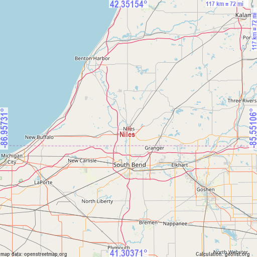
Niles GPS coordinates[2]
41° 49' 47.172" North, 86° 15' 15.048" West
| Map corner | latitude | longitude |
|---|---|---|
| Upper-left | 42.35154°, | -86.95731° |
| Center: | 41.82977°, | -86.25418° |
| Lower-right: | 41.30371°, | -85.55106° |
| Map W x H: | 116.5×116.5 km | = 72.4×72.4mi |
| max Lat: | 71.29058° ⇑25.8% North |
| Niles: | 41.82977° |
| min Lat: | ⇓74.2% South 19.06759° |
| min Long | Niles | max Long |
| -171.73463° | -86.25418° | -66.98998° |
| W 52.2%⇐ | ⇒47.8% E |
Elevation
Elevation of Niles is 211 m = 692 ft, and this is 83.8 m = 275 ft below average elevation for this country.
| Max E: |
3189 m = 10463 ft | 46.8% |
| Avg. | 294.8 m = 967 ft | |
| Niles | 211 m = 692 ft | |
Min E: |
-60 m = -197 ft | 53.2% |
See also: United States elevation on elevation.city.
Geographical zone
Niles is located in North temperate zone (between Tropic of Cancer and the Arctic Circle). Distance of this Northern Tropic circle is 2045.1 km =1270.8 mi to South.| Distance of | km | miles | from Niles |
|---|---|---|---|
| North Pole | 5356 | 3328.1 | to North |
| Arctic Circle | 2750.1 | 1708.8 | to North |
| Tropic Cancer | 2045.1 | 1270.8 | to South |
| Equator | 4651 | 2890 | to South |


Nearby cities:
15 places around Niles: (largest is in red/bold)
• Baroda
23.8 km =14.8 mi,  306°
306°
• Berrien Springs
14.7 km =9.1 mi,  331°
331°
• Buchanan
8.9 km =5.5 mi,  268°
268°
• Cassopolis
22.2 km =13.8 mi,  65°
65°
• Dowagiac
21 km =13 mi,  35°
35°
• Eau Claire
17.7 km =11 mi,  347°
347°
• Edwardsburg
14.9 km =9.3 mi,  104°
104°
• Galien
20.6 km =12.8 mi,  260°
260°
• Georgetown
11.4 km =7.1 mi,  169°
169°
• Granger
14.6 km =9.1 mi,  125°
125°
• Mishawaka
20.3 km =12.6 mi,  156°
156°
• Notre Dame
14.5 km =9 mi, 174°
• Osceola
23.5 km =14.6 mi,  141°
141°
• Roseland
12.6 km =7.8 mi,  179°
179°
• South Bend
16.3 km =10.1 mi, 178°
Sources, notices
• [Note1] Compared only with cities in United States existing in our database
• [Src1] Map data: © OpenStreetMap contributors (CC-BY-SA)
• [Src2] Other city data from geonames.org with taken over terms of usage.
• [Src3] Geographical zone / Annual Mean Temperature by Robert A. Rohde @ Wikipedia
