Chums Corner geodata
Chums Corner (Michigan) is a populated place; located in United States in America/Detroit (GMT-4) time zone. With population of 946 people, there are 16667 cities with bigger population in this country. Compared to other cities in United States, 91.2% of cities are located further ↓South; 54% of cities are located further ←West and 66.6% of cities have lower elevation than Chums Corner. Note1
Administrative division(s):
- Level 1: Michigan
- Level 2: Grand Traverse County
- Level 3: Township of Blair


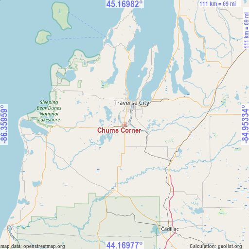
Chums Corner GPS coordinates[2]
44° 40' 19.02" North, 85° 39' 23.256" West
| Map corner | latitude | longitude |
|---|---|---|
| Upper-left | 45.16982°, | -86.35959° |
| Center: | 44.67195°, | -85.65646° |
| Lower-right: | 44.16977°, | -84.95334° |
| Map W x H: | 111.2×111.2 km | = 69.1×69.1mi |
| max Lat: | 71.29058° ⇑8.8% North |
| Chums Corner: | 44.67195° |
| min Lat: | ⇓91.2% South 19.06759° |
| min Long | Chums Corner | max Long |
| -171.73463° | -85.65646° | -66.98998° |
| W 54%⇐ | ⇒46% E |
Elevation
Elevation of Chums Corner is 269 m = 883 ft, and this is 25.8 m = 85 ft below average elevation for this country.
| Max E: |
3189 m = 10463 ft | 33.4% |
| Avg. | 294.8 m = 967 ft | |
| Chums Corner | 269 m = 883 ft | |
Min E: |
-60 m = -197 ft | 66.6% |
See also: United States elevation on elevation.city.
Geographical zone
Chums Corner is located in North temperate zone (between Tropic of Cancer and the Arctic Circle). Distance of this Northern Tropic circle is 2361.1 km =1467.1 mi to South.| Distance of | km | miles | from Chums Corner |
|---|---|---|---|
| North Pole | 5040 | 3131.7 | to North |
| Arctic Circle | 2434.1 | 1512.5 | to North |
| Tropic Cancer | 2361.1 | 1467.1 | to South |
| Equator | 4967.1 | 3086.4 | to South |


Nearby cities:
15 places around Chums Corner: (largest is in red/bold)
• Beulah
34.7 km =21.6 mi,  262°
262°
• Buckley
18.7 km =11.6 mi,  184°
184°
• Elk Rapids
31.3 km =19.4 mi,  37°
37°
• Frankfort
45.9 km =28.5 mi, 264°
• Grawn
3.1 km =1.9 mi,  250°
250°
• Greilickville
12.4 km =7.7 mi,  6°
6°
• Interlochen
9.3 km =5.8 mi, 250°
• Kalkaska
38.6 km =24 mi,  79°
79°
• Kingsley
13.6 km =8.5 mi,  135°
135°
• Leland
39.9 km =24.8 mi,  348°
348°
• Manton
35.5 km =22.1 mi, 144°
• Rapid City
34.6 km =21.5 mi,  58°
58°
• South Boardman
30 km =18.6 mi,  96°
96°
• Suttons Bay
33.9 km =21.1 mi,  0°
0°
• Traverse City
10.5 km =6.5 mi,  15°
15°
Sources, notices
• [Note1] Compared only with cities in United States existing in our database
• [Src1] Map data: © OpenStreetMap contributors (CC-BY-SA)
• [Src2] Other city data from geonames.org with taken over terms of usage.
• [Src3] Geographical zone / Annual Mean Temperature by Robert A. Rohde @ Wikipedia
