Traverse City geodata
Traverse City (Michigan) is a seat of a second-order administrative division; located in United States in America/Detroit (GMT-4) time zone. With population of 15,218 people, there are 3200 cities with bigger population in this country. Compared to other cities in United States, 91.5% of cities are located further ↓South; 54.2% of cities are located further ←West and 55.1% of cities have higher elevation than Traverse City. Note1
Administrative division(s):
- Level 1: Michigan
- Level 2: Grand Traverse County
- Level 3: City of Traverse City


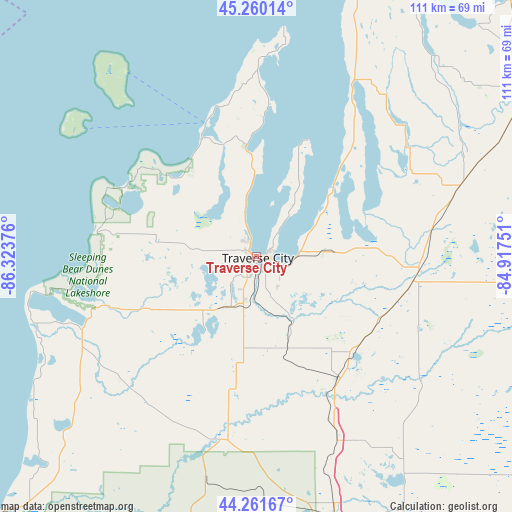
Traverse City GPS coordinates[2]
44° 45' 47.016" North, 85° 37' 14.268" West
| Map corner | latitude | longitude |
|---|---|---|
| Upper-left | 45.26014°, | -86.32376° |
| Center: | 44.76306°, | -85.62063° |
| Lower-right: | 44.26167°, | -84.91751° |
| Map W x H: | 111×111 km | = 69×69mi |
| max Lat: | 71.29058° ⇑8.5% North |
| Traverse City: | 44.76306° |
| min Lat: | ⇓91.5% South 19.06759° |
| min Long | Traverse City | max Long |
| -171.73463° | -85.62063° | -66.98998° |
| W 54.2%⇐ | ⇒45.8% E |
Elevation
Elevation of Traverse City is 180 m = 591 ft, and this is 114.8 m = 377 ft below average elevation for this country.
| Max E: |
3189 m = 10463 ft | 55.1% |
| Avg. | 294.8 m = 967 ft | |
| Traverse City | 180 m = 591 ft | |
Min E: |
-60 m = -197 ft | 44.9% |
See also: United States elevation on elevation.city.
Geographical zone
Traverse City is located in North temperate zone (between Tropic of Cancer and the Arctic Circle). Distance of this Northern Tropic circle is 2371.3 km =1473.5 mi to South.| Distance of | km | miles | from Traverse City |
|---|---|---|---|
| North Pole | 5029.9 | 3125.4 | to North |
| Arctic Circle | 2424 | 1506.2 | to North |
| Tropic Cancer | 2371.3 | 1473.5 | to South |
| Equator | 4977.2 | 3092.7 | to South |


Nearby cities:
15 places around Traverse City: (largest is in red/bold)
• Bellaire
40.3 km =25 mi,  53°
53°
• Beulah
39.9 km =24.8 mi,  248°
248°
• Buckley
29.1 km =18.1 mi,  188°
188°
• Chums Corner
10.5 km =6.5 mi,  195°
195°
• Elk Rapids
21.8 km =13.5 mi, 47°
• Grawn
12.6 km =7.8 mi,  207°
207°
• Greilickville
2.6 km =1.6 mi,  327°
327°
• Interlochen
17.5 km =10.9 mi,  221°
221°
• Kalkaska
35.3 km =21.9 mi,  95°
95°
• Kingsley
20.9 km =13 mi,  161°
161°
• Leland
30.9 km =19.2 mi,  339°
339°
• Northport
41 km =25.5 mi,  0°
0°
• Rapid City
27.8 km =17.3 mi,  73°
73°
• South Boardman
30.1 km =18.7 mi,  116°
116°
• Suttons Bay
23.9 km =14.9 mi,  354°
354°
Sources, notices
• [Note1] Compared only with cities in United States existing in our database
• [Src1] Map data: © OpenStreetMap contributors (CC-BY-SA)
• [Src2] Other city data from geonames.org with taken over terms of usage.
• [Src3] Geographical zone / Annual Mean Temperature by Robert A. Rohde @ Wikipedia
