Beulah geodata
Beulah (Michigan) is a seat of a second-order administrative division; located in United States in America/Detroit (GMT-4) time zone. With population of 341 people, there are 20958 cities with bigger population in this country. Compared to other cities in United States, 91% of cities are located further ↓South; 52.7% of cities are located further ←West and 53.9% of cities have higher elevation than Beulah. Note1


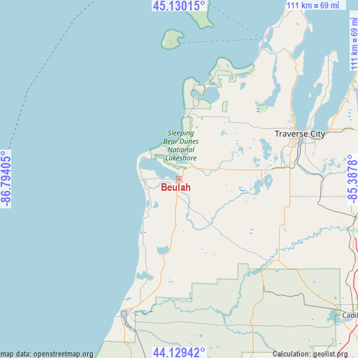
Beulah GPS coordinates[2]
44° 37' 54.984" North, 86° 5' 27.312" West
| Map corner | latitude | longitude |
|---|---|---|
| Upper-left | 45.13015°, | -86.79405° |
| Center: | 44.63194°, | -86.09092° |
| Lower-right: | 44.12942°, | -85.3878° |
| Map W x H: | 111.3×111.3 km | = 69.2×69.2mi |
| max Lat: | 71.29058° ⇑9% North |
| Beulah: | 44.63194° |
| min Lat: | ⇓91% South 19.06759° |
| min Long | Beulah | max Long |
| -171.73463° | -86.09092° | -66.98998° |
| W 52.7%⇐ | ⇒47.3% E |
Elevation
Elevation of Beulah is 184 m = 604 ft, and this is 110.8 m = 364 ft below average elevation for this country.
| Max E: |
3189 m = 10463 ft | 53.9% |
| Avg. | 294.8 m = 967 ft | |
| Beulah | 184 m = 604 ft | |
Min E: |
-60 m = -197 ft | 46.1% |
See also: United States elevation on elevation.city.
Geographical zone
Beulah is located in North temperate zone (between Tropic of Cancer and the Arctic Circle). Distance of this Northern Tropic circle is 2356.7 km =1464.4 mi to South.| Distance of | km | miles | from Beulah |
|---|---|---|---|
| North Pole | 5044.5 | 3134.5 | to North |
| Arctic Circle | 2438.6 | 1515.3 | to North |
| Tropic Cancer | 2356.7 | 1464.4 | to South |
| Equator | 4962.6 | 3083.6 | to South |


Nearby cities:
15 places around Beulah: (largest is in red/bold)
• Buckley
35.7 km =22.2 mi,  113°
113°
• Chums Corner
34.7 km =21.6 mi,  82°
82°
• Elk Rapids
60.8 km =37.8 mi,  61°
61°
• Frankfort
11.4 km =7.1 mi,  270°
270°
• Grawn
31.6 km =19.6 mi, 83°
• Greilickville
39.5 km =24.5 mi, 64°
• Interlochen
25.6 km =15.9 mi,  86°
86°
• Kingsley
44.2 km =27.5 mi,  96°
96°
• Leland
50.7 km =31.5 mi,  30°
30°
• Manistee
46.9 km =29.1 mi,  203°
203°
• Manton
60.1 km =37.3 mi, 114°
• Oak Hill
48.4 km =30.1 mi, 200°
• Parkdale
43.9 km =27.3 mi, 202°
• Suttons Bay
51.7 km =32.1 mi,  42°
42°
• Traverse City
39.9 km =24.8 mi,  68°
68°
Sources, notices
• [Note1] Compared only with cities in United States existing in our database
• [Src1] Map data: © OpenStreetMap contributors (CC-BY-SA)
• [Src2] Other city data from geonames.org with taken over terms of usage.
• [Src3] Geographical zone / Annual Mean Temperature by Robert A. Rohde @ Wikipedia
