Flint geodata
Flint (Michigan) is a seat of a second-order administrative division; located in United States in America/Detroit (GMT-4) time zone. With population of 98,310 people, there are 362 cities with bigger population in this country. Compared to other cities in United States, 83.4% of cities are located further ↓South; 60.2% of cities are located further ←West and 58.2% of cities have lower elevation than Flint. Note1


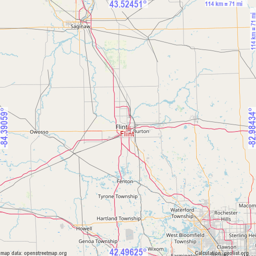
Flint GPS coordinates[2]
43° 0' 45.108" North, 83° 41' 14.856" West
| Map corner | latitude | longitude |
|---|---|---|
| Upper-left | 43.52451°, | -84.39059° |
| Center: | 43.01253°, | -83.68746° |
| Lower-right: | 42.49625°, | -82.98434° |
| Map W x H: | 114.3×114.3 km | = 71×71mi |
| max Lat: | 71.29058° ⇑16.6% North |
| Flint: | 43.01253° |
| min Lat: | ⇓83.4% South 19.06759° |
| min Long | Flint | max Long |
| -171.73463° | -83.68746° | -66.98998° |
| W 60.2%⇐ | ⇒39.8% E |
Elevation
Elevation of Flint is 231 m = 758 ft, and this is 63.8 m = 209 ft below average elevation for this country.
| Max E: |
3189 m = 10463 ft | 41.8% |
| Avg. | 294.8 m = 967 ft | |
| Flint | 231 m = 758 ft | |
Min E: |
-60 m = -197 ft | 58.2% |
See also: Flint elevation on elevation.city.
Geographical zone
Flint is located in North temperate zone (between Tropic of Cancer and the Arctic Circle). Distance of this Northern Tropic circle is 2176.6 km =1352.5 mi to South.| Distance of | km | miles | from Flint |
|---|---|---|---|
| North Pole | 5224.5 | 3246.4 | to North |
| Arctic Circle | 2618.6 | 1627.1 | to North |
| Tropic Cancer | 2176.6 | 1352.5 | to South |
| Equator | 4782.5 | 2971.7 | to South |


Nearby cities:
15 places around Flint: (largest is in red/bold)
• Beecher
8.6 km =5.3 mi,  356°
356°
• Burton
6 km =3.7 mi,  104°
104°
• Clio
18.7 km =11.6 mi,  348°
348°
• Davison
14 km =8.7 mi,  79°
79°
• Fenton
23.9 km =14.9 mi,  183°
183°
• Flushing
14.4 km =8.9 mi,  292°
292°
• Goodrich
18.2 km =11.3 mi,  125°
125°
• Grand Blanc
10.5 km =6.5 mi,  153°
153°
• Lake Fenton
18.6 km =11.6 mi,  185°
185°
• Lennon
20 km =12.4 mi,  261°
261°
• Linden
23.3 km =14.5 mi,  199°
199°
• Montrose
24.7 km =15.3 mi,  317°
317°
• Mount Morris
11.8 km =7.3 mi, 357°
• Otisville
21.6 km =13.4 mi,  37°
37°
• Swartz Creek
13.2 km =8.2 mi,  242°
242°
Sources, notices
• [Note1] Compared only with cities in United States existing in our database
• [Src1] Map data: © OpenStreetMap contributors (CC-BY-SA)
• [Src2] Other city data from geonames.org with taken over terms of usage.
• [Src3] Geographical zone / Annual Mean Temperature by Robert A. Rohde @ Wikipedia
