Lake Fenton geodata
Lake Fenton (Michigan) is a populated place; located in United States in America/Detroit (GMT-4) time zone. With population of 5,559 people, there are 6716 cities with bigger population in this country. Compared to other cities in United States, 82.2% of cities are located further ↓South; 60.1% of cities are located further ←West and 67.4% of cities have lower elevation than Lake Fenton. Note1
Administrative division(s):
- Level 1: Michigan
- Level 2: Genesee County
- Level 3: Charter Township of Fenton


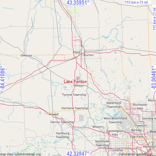
Lake Fenton GPS coordinates[2]
42° 50' 46.104" North, 83° 42' 27.828" West
| Map corner | latitude | longitude |
|---|---|---|
| Upper-left | 43.35951°, | -84.41086° |
| Center: | 42.84614°, | -83.70773° |
| Lower-right: | 42.32847°, | -83.00461° |
| Map W x H: | 114.6×114.6 km | = 71.2×71.2mi |
| max Lat: | 71.29058° ⇑17.8% North |
| Lake Fenton: | 42.84614° |
| min Lat: | ⇓82.2% South 19.06759° |
| min Long | Lake Fenton | max Long |
| -171.73463° | -83.70773° | -66.98998° |
| W 60.1%⇐ | ⇒39.9% E |
Elevation
Elevation of Lake Fenton is 273 m = 896 ft, and this is 21.8 m = 72 ft below average elevation for this country.
| Max E: |
3189 m = 10463 ft | 32.6% |
| Avg. | 294.8 m = 967 ft | |
| Lake Fenton | 273 m = 896 ft | |
Min E: |
-60 m = -197 ft | 67.4% |
See also: United States elevation on elevation.city.
Geographical zone
Lake Fenton is located in North temperate zone (between Tropic of Cancer and the Arctic Circle). Distance of this Northern Tropic circle is 2158.1 km =1341 mi to South.| Distance of | km | miles | from Lake Fenton |
|---|---|---|---|
| North Pole | 5243 | 3257.8 | to North |
| Arctic Circle | 2637.1 | 1638.6 | to North |
| Tropic Cancer | 2158.1 | 1341 | to South |
| Equator | 4764 | 2960.2 | to South |


Nearby cities:
15 places around Lake Fenton: (largest is in red/bold)
• Argentine
12.8 km =8 mi,  241°
241°
• Burton
18.6 km =11.6 mi,  23°
23°
• Byron
19.5 km =12.1 mi,  262°
262°
• Clarkston
26.6 km =16.5 mi,  117°
117°
• Davison
26 km =16.2 mi,  36°
36°
• Durand
23.7 km =14.7 mi,  287°
287°
• Fenton
5.4 km =3.4 mi,  177°
177°
• Flint
18.6 km =11.6 mi,  5°
5°
• Goodrich
18.2 km =11.3 mi,  64°
64°
• Grand Blanc
11 km =6.8 mi,  34°
34°
• Holly
8.9 km =5.5 mi,  132°
132°
• Lennon
23.8 km =14.8 mi,  310°
310°
• Linden
7 km =4.3 mi, 239°
• Ortonville
21.6 km =13.4 mi,  88°
88°
• Swartz Creek
15.9 km =9.9 mi,  321°
321°
Sources, notices
• [Note1] Compared only with cities in United States existing in our database
• [Src1] Map data: © OpenStreetMap contributors (CC-BY-SA)
• [Src2] Other city data from geonames.org with taken over terms of usage.
• [Src3] Geographical zone / Annual Mean Temperature by Robert A. Rohde @ Wikipedia
