Frankenmuth geodata
Frankenmuth (Michigan) is a populated place; located in United States in America/Detroit (GMT-4) time zone. With population of 5,025 people, there are 7147 cities with bigger population in this country. Compared to other cities in United States, 85.6% of cities are located further ↓South; 60% of cities are located further ←West and 51.1% of cities have higher elevation than Frankenmuth. Note1


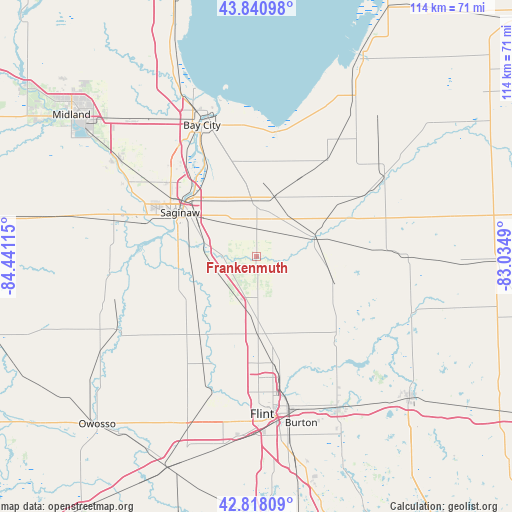
Frankenmuth GPS coordinates[2]
43° 19' 54.084" North, 83° 44' 16.872" West
| Map corner | latitude | longitude |
|---|---|---|
| Upper-left | 43.84098°, | -84.44115° |
| Center: | 43.33169°, | -83.73802° |
| Lower-right: | 42.81809°, | -83.0349° |
| Map W x H: | 113.7×113.7 km | = 70.6×70.6mi |
| max Lat: | 71.29058° ⇑14.4% North |
| Frankenmuth: | 43.33169° |
| min Lat: | ⇓85.6% South 19.06759° |
| min Long | Frankenmuth | max Long |
| -171.73463° | -83.73802° | -66.98998° |
| W 60%⇐ | ⇒40% E |
Elevation
Elevation of Frankenmuth is 194 m = 636 ft, and this is 100.8 m = 331 ft below average elevation for this country.
| Max E: |
3189 m = 10463 ft | 51.1% |
| Avg. | 294.8 m = 967 ft | |
| Frankenmuth | 194 m = 636 ft | |
Min E: |
-60 m = -197 ft | 48.9% |
See also: United States elevation on elevation.city.
Geographical zone
Frankenmuth is located in North temperate zone (between Tropic of Cancer and the Arctic Circle). Distance of this Northern Tropic circle is 2212.1 km =1374.5 mi to South.| Distance of | km | miles | from Frankenmuth |
|---|---|---|---|
| North Pole | 5189 | 3224.3 | to North |
| Arctic Circle | 2583.1 | 1605.1 | to North |
| Tropic Cancer | 2212.1 | 1374.5 | to South |
| Equator | 4818 | 2993.8 | to South |


Nearby cities:
15 places around Frankenmuth: (largest is in red/bold)
• Birch Run
10.1 km =6.3 mi,  206°
206°
• Bridgeport
12 km =7.5 mi,  284°
284°
• Buena Vista
16.3 km =10.1 mi,  307°
307°
• Burt
17.2 km =10.7 mi,  232°
232°
• Carrollton
21 km =13 mi, 312°
• Clio
17.1 km =10.6 mi,  178°
178°
• Millington
17.8 km =11.1 mi,  108°
108°
• Montrose
21.3 km =13.2 mi,  216°
216°
• Mount Morris
23.9 km =14.9 mi,  171°
171°
• Otisville
25.3 km =15.7 mi,  136°
136°
• Reese
13.6 km =8.5 mi,  14°
14°
• Robin Glen-Indiantown
16.6 km =10.3 mi,  331°
331°
• Saginaw
19.8 km =12.3 mi,  299°
299°
• Vassar
13.3 km =8.3 mi,  70°
70°
• Zilwaukee
21.8 km =13.5 mi,  317°
317°
Sources, notices
• [Note1] Compared only with cities in United States existing in our database
• [Src1] Map data: © OpenStreetMap contributors (CC-BY-SA)
• [Src2] Other city data from geonames.org with taken over terms of usage.
• [Src3] Geographical zone / Annual Mean Temperature by Robert A. Rohde @ Wikipedia
