Birch Run geodata
Birch Run (Michigan) is a populated place; located in United States in America/Detroit (GMT-4) time zone. With population of 1,479 people, there are 13756 cities with bigger population in this country. Compared to other cities in United States, 85.2% of cities are located further ↓South; 59.8% of cities are located further ←West and 50.3% of cities have higher elevation than Birch Run. Note1
Administrative division(s):
- Level 1: Michigan
- Level 2: Saginaw County
- Level 3: Township of Birch Run


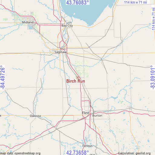
Birch Run GPS coordinates[2]
43° 15' 3.096" North, 83° 47' 38.868" West
| Map corner | latitude | longitude |
|---|---|---|
| Upper-left | 43.76083°, | -84.49726° |
| Center: | 43.25086°, | -83.79413° |
| Lower-right: | 42.73658°, | -83.09101° |
| Map W x H: | 113.9×113.9 km | = 70.8×70.8mi |
| max Lat: | 71.29058° ⇑14.8% North |
| Birch Run: | 43.25086° |
| min Lat: | ⇓85.2% South 19.06759° |
| min Long | Birch Run | max Long |
| -171.73463° | -83.79413° | -66.98998° |
| W 59.8%⇐ | ⇒40.2% E |
Elevation
Elevation of Birch Run is 197 m = 646 ft, and this is 97.8 m = 321 ft below average elevation for this country.
| Max E: |
3189 m = 10463 ft | 50.3% |
| Avg. | 294.8 m = 967 ft | |
| Birch Run | 197 m = 646 ft | |
Min E: |
-60 m = -197 ft | 49.7% |
See also: United States elevation on elevation.city.
Geographical zone
Birch Run is located in North temperate zone (between Tropic of Cancer and the Arctic Circle). Distance of this Northern Tropic circle is 2203.1 km =1368.9 mi to South.| Distance of | km | miles | from Birch Run |
|---|---|---|---|
| North Pole | 5198 | 3229.9 | to North |
| Arctic Circle | 2592.1 | 1610.7 | to North |
| Tropic Cancer | 2203.1 | 1368.9 | to South |
| Equator | 4809 | 2988.2 | to South |


Nearby cities:
15 places around Birch Run: (largest is in red/bold)
• Beecher
19.6 km =12.2 mi,  155°
155°
• Bridgeport
14 km =8.7 mi,  329°
329°
• Buena Vista
20.6 km =12.8 mi,  335°
335°
• Burt
9.2 km =5.7 mi,  260°
260°
• Clio
9.5 km =5.9 mi,  149°
149°
• Flushing
21.4 km =13.3 mi,  192°
192°
• Frankenmuth
10.1 km =6.3 mi,  26°
26°
• Millington
21.7 km =13.5 mi,  80°
80°
• Montrose
11.5 km =7.1 mi,  224°
224°
• Mount Morris
16.8 km =10.4 mi, 151°
• New Lothrop
20.6 km =12.8 mi, 223°
• Reese
23.6 km =14.7 mi,  19°
19°
• Robin Glen-Indiantown
23.7 km =14.7 mi,  351°
351°
• Saginaw
22.6 km =14 mi, 325°
• Vassar
21.7 km =13.5 mi,  51°
51°
Sources, notices
• [Note1] Compared only with cities in United States existing in our database
• [Src1] Map data: © OpenStreetMap contributors (CC-BY-SA)
• [Src2] Other city data from geonames.org with taken over terms of usage.
• [Src3] Geographical zone / Annual Mean Temperature by Robert A. Rohde @ Wikipedia
