Kentwood geodata
Kentwood (Michigan) is a populated place; located in United States in America/Detroit (GMT-4) time zone. With population of 51,357 people, there are 926 cities with bigger population in this country. Compared to other cities in United States, 82.3% of cities are located further ↓South; 54% of cities are located further ←West and 53.5% of cities have lower elevation than Kentwood. Note1


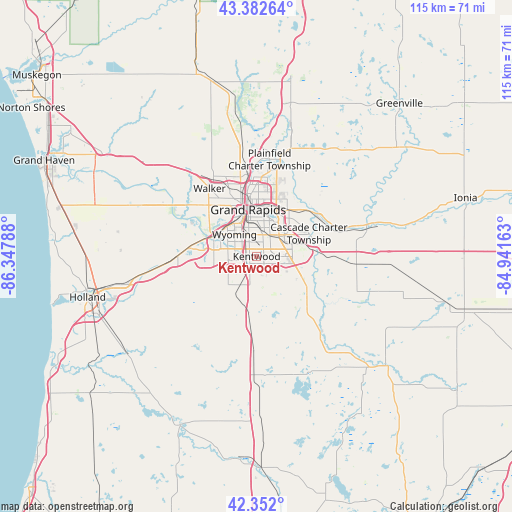
Kentwood GPS coordinates[2]
42° 52' 10.092" North, 85° 38' 41.1" West
| Map corner | latitude | longitude |
|---|---|---|
| Upper-left | 43.38264°, | -86.34788° |
| Center: | 42.86947°, | -85.64475° |
| Lower-right: | 42.352°, | -84.94163° |
| Map W x H: | 114.6×114.6 km | = 71.2×71.2mi |
| max Lat: | 71.29058° ⇑17.7% North |
| Kentwood: | 42.86947° |
| min Lat: | ⇓82.3% South 19.06759° |
| min Long | Kentwood | max Long |
| -171.73463° | -85.64475° | -66.98998° |
| W 54%⇐ | ⇒46% E |
Elevation
Elevation of Kentwood is 212 m = 696 ft, and this is 82.8 m = 272 ft below average elevation for this country.
| Max E: |
3189 m = 10463 ft | 46.5% |
| Avg. | 294.8 m = 967 ft | |
| Kentwood | 212 m = 696 ft | |
Min E: |
-60 m = -197 ft | 53.5% |
See also: Kentwood elevation on elevation.city.
Geographical zone
Kentwood is located in North temperate zone (between Tropic of Cancer and the Arctic Circle). Distance of this Northern Tropic circle is 2160.7 km =1342.6 mi to South.| Distance of | km | miles | from Kentwood |
|---|---|---|---|
| North Pole | 5240.4 | 3256.2 | to North |
| Arctic Circle | 2634.5 | 1637 | to North |
| Tropic Cancer | 2160.7 | 1342.6 | to South |
| Equator | 4766.6 | 2961.8 | to South |


Nearby cities:
15 places around Kentwood: (largest is in red/bold)
• Byron Center
9 km =5.6 mi,  225°
225°
• Caledonia
13.7 km =8.5 mi,  130°
130°
• Comstock Park
18.9 km =11.7 mi,  353°
353°
• Cutlerville
3.5 km =2.2 mi,  205°
205°
• East Grand Rapids
8.5 km =5.3 mi,  19°
19°
• Forest Hills
16.1 km =10 mi,  51°
51°
• Grand Rapids
10.6 km =6.6 mi, 349°
• Grandville
10.6 km =6.6 mi,  294°
294°
• Hudsonville
18 km =11.2 mi,  270°
270°
• Jenison
12.7 km =7.9 mi, 289°
• Middleville
22.9 km =14.2 mi,  139°
139°
• Northview
19.9 km =12.4 mi,  10°
10°
• Walker
17.8 km =11.1 mi,  325°
325°
• Wayland
21.7 km =13.5 mi,  179°
179°
• Wyoming
6.9 km =4.3 mi,  314°
314°
Sources, notices
• [Note1] Compared only with cities in United States existing in our database
• [Src1] Map data: © OpenStreetMap contributors (CC-BY-SA)
• [Src2] Other city data from geonames.org with taken over terms of usage.
• [Src3] Geographical zone / Annual Mean Temperature by Robert A. Rohde @ Wikipedia
