Wyoming geodata
Wyoming (Michigan) is a populated place; located in United States in America/Detroit (GMT-4) time zone. With population of 75,275 people, there are 537 cities with bigger population in this country. Compared to other cities in United States, 82.7% of cities are located further ↓South; 53.8% of cities are located further ←West and 50.2% of cities have lower elevation than Wyoming. Note1


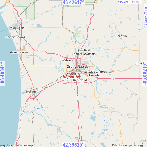
Wyoming GPS coordinates[2]
42° 54' 48.096" North, 85° 42' 19.116" West
| Map corner | latitude | longitude |
|---|---|---|
| Upper-left | 43.42617°, | -86.40844° |
| Center: | 42.91336°, | -85.70531° |
| Lower-right: | 42.39625°, | -85.00219° |
| Map W x H: | 114.5×114.5 km | = 71.1×71.1mi |
| max Lat: | 71.29058° ⇑17.3% North |
| Wyoming: | 42.91336° |
| min Lat: | ⇓82.7% South 19.06759° |
| min Long | Wyoming | max Long |
| -171.73463° | -85.70531° | -66.98998° |
| W 53.8%⇐ | ⇒46.2% E |
Elevation
Elevation of Wyoming is 199 m = 653 ft, and this is 95.8 m = 314 ft below average elevation for this country.
| Max E: |
3189 m = 10463 ft | 49.8% |
| Avg. | 294.8 m = 967 ft | |
| Wyoming | 199 m = 653 ft | |
Min E: |
-60 m = -197 ft | 50.2% |
See also: Wyoming elevation on elevation.city.
Geographical zone
Wyoming is located in North temperate zone (between Tropic of Cancer and the Arctic Circle). Distance of this Northern Tropic circle is 2165.6 km =1345.6 mi to South.| Distance of | km | miles | from Wyoming |
|---|---|---|---|
| North Pole | 5235.5 | 3253.2 | to North |
| Arctic Circle | 2629.7 | 1634 | to North |
| Tropic Cancer | 2165.6 | 1345.6 | to South |
| Equator | 4771.5 | 2964.9 | to South |


Nearby cities:
15 places around Wyoming: (largest is in red/bold)
• Allendale
21.2 km =13.2 mi,  287°
287°
• Byron Center
11.3 km =7 mi,  187°
187°
• Caledonia
20.7 km =12.9 mi,  131°
131°
• Comstock Park
14.2 km =8.8 mi,  11°
11°
• Coopersville
25.1 km =15.6 mi,  311°
311°
• Cutlerville
8.7 km =5.4 mi,  157°
157°
• East Grand Rapids
8.3 km =5.2 mi,  68°
68°
• Forest Hills
18.3 km =11.4 mi, 73°
• Grand Rapids
6.3 km =3.9 mi,  28°
28°
• Grandville
4.7 km =2.9 mi,  265°
265°
• Hudsonville
13.8 km =8.6 mi,  250°
250°
• Jenison
7.1 km =4.4 mi,  264°
264°
• Kentwood
6.9 km =4.3 mi, 134°
• Northview
17 km =10.6 mi, 30°
• Walker
11 km =6.8 mi,  332°
332°
Sources, notices
• [Note1] Compared only with cities in United States existing in our database
• [Src1] Map data: © OpenStreetMap contributors (CC-BY-SA)
• [Src2] Other city data from geonames.org with taken over terms of usage.
• [Src3] Geographical zone / Annual Mean Temperature by Robert A. Rohde @ Wikipedia
