Holly geodata
Holly (Michigan) is a populated place; located in United States in America/Detroit (GMT-4) time zone. With population of 6,169 people, there are 6295 cities with bigger population in this country. Compared to other cities in United States, 81.8% of cities are located further ↓South; 60.3% of cities are located further ←West and 69.7% of cities have lower elevation than Holly. Note1


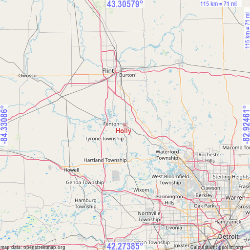
Holly GPS coordinates[2]
42° 47' 31.092" North, 83° 37' 39.828" West
| Map corner | latitude | longitude |
|---|---|---|
| Upper-left | 43.30579°, | -84.33086° |
| Center: | 42.79197°, | -83.62773° |
| Lower-right: | 42.27385°, | -82.92461° |
| Map W x H: | 114.7×114.7 km | = 71.3×71.3mi |
| max Lat: | 71.29058° ⇑18.2% North |
| Holly: | 42.79197° |
| min Lat: | ⇓81.8% South 19.06759° |
| min Long | Holly | max Long |
| -171.73463° | -83.62773° | -66.98998° |
| W 60.3%⇐ | ⇒39.7% E |
Elevation
Elevation of Holly is 284 m = 932 ft, and this is 10.8 m = 35 ft below average elevation for this country.
| Max E: |
3189 m = 10463 ft | 30.3% |
| Avg. | 294.8 m = 967 ft | |
| Holly | 284 m = 932 ft | |
Min E: |
-60 m = -197 ft | 69.7% |
See also: United States elevation on elevation.city.
Geographical zone
Holly is located in North temperate zone (between Tropic of Cancer and the Arctic Circle). Distance of this Northern Tropic circle is 2152.1 km =1337.3 mi to South.| Distance of | km | miles | from Holly |
|---|---|---|---|
| North Pole | 5249 | 3261.6 | to North |
| Arctic Circle | 2643.2 | 1642.4 | to North |
| Tropic Cancer | 2152.1 | 1337.3 | to South |
| Equator | 4758 | 2956.5 | to South |


Nearby cities:
15 places around Holly: (largest is in red/bold)
• Argentine
17.8 km =11.1 mi,  269°
269°
• Burton
23.1 km =14.4 mi,  2°
2°
• Byron
26.1 km =16.2 mi,  277°
277°
• Clarkston
18.2 km =11.3 mi,  110°
110°
• Davison
28.4 km =17.6 mi,  18°
18°
• Fenton
6.3 km =3.9 mi, 275°
• Flint
25 km =15.5 mi,  348°
348°
• Goodrich
17.1 km =10.6 mi,  35°
35°
• Grand Blanc
15.1 km =9.4 mi,  359°
359°
• Lake Fenton
8.9 km =5.5 mi,  312°
312°
• Linden
12.9 km =8 mi, 281°
• Milford
22.2 km =13.8 mi,  174°
174°
• Ortonville
16.5 km =10.3 mi,  66°
66°
• Swartz Creek
24.7 km =15.3 mi,  318°
318°
• Waterford
20.8 km =12.9 mi,  121°
121°
Sources, notices
• [Note1] Compared only with cities in United States existing in our database
• [Src1] Map data: © OpenStreetMap contributors (CC-BY-SA)
• [Src2] Other city data from geonames.org with taken over terms of usage.
• [Src3] Geographical zone / Annual Mean Temperature by Robert A. Rohde @ Wikipedia
