Luna Pier geodata
Luna Pier (Michigan) is a populated place; located in United States in America/Detroit (GMT-4) time zone. With population of 1,389 people, there are 14162 cities with bigger population in this country. Compared to other cities in United States, 74% of cities are located further ↓South; 60.8% of cities are located further ←West and 56% of cities have higher elevation than Luna Pier. Note1


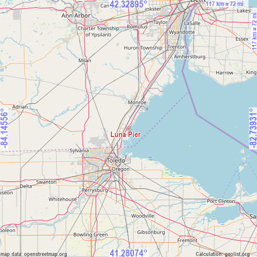
Luna Pier GPS coordinates[2]
41° 48' 25.164" North, 83° 26' 32.748" West
| Map corner | latitude | longitude |
|---|---|---|
| Upper-left | 42.32895°, | -84.14556° |
| Center: | 41.80699°, | -83.44243° |
| Lower-right: | 41.28074°, | -82.73931° |
| Map W x H: | 116.6×116.5 km | = 72.5×72.4mi |
| max Lat: | 71.29058° ⇑26% North |
| Luna Pier: | 41.80699° |
| min Lat: | ⇓74% South 19.06759° |
| min Long | Luna Pier | max Long |
| -171.73463° | -83.44243° | -66.98998° |
| W 60.8%⇐ | ⇒39.2% E |
Elevation
Elevation of Luna Pier is 176 m = 577 ft, and this is 118.8 m = 390 ft below average elevation for this country.
| Max E: |
3189 m = 10463 ft | 56% |
| Avg. | 294.8 m = 967 ft | |
| Luna Pier | 176 m = 577 ft | |
Min E: |
-60 m = -197 ft | 44% |
See also: United States elevation on elevation.city.
Geographical zone
Luna Pier is located in North temperate zone (between Tropic of Cancer and the Arctic Circle). Distance of this Northern Tropic circle is 2042.6 km =1269.2 mi to South.| Distance of | km | miles | from Luna Pier |
|---|---|---|---|
| North Pole | 5358.6 | 3329.7 | to North |
| Arctic Circle | 2752.7 | 1710.4 | to North |
| Tropic Cancer | 2042.6 | 1269.2 | to South |
| Equator | 4648.5 | 2888.4 | to South |


Nearby cities:
15 places around Luna Pier: (largest is in red/bold)
• Curtice
21.9 km =13.6 mi,  163°
163°
• Detroit Beach
16.8 km =10.4 mi,  34°
34°
• Lambertville
16 km =9.9 mi,  253°
253°
• Maybee
22.7 km =14.1 mi,  344°
344°
• Monroe
12.7 km =7.9 mi,  16°
16°
• Northwood
22.3 km =13.9 mi,  185°
185°
• Oregon
18.5 km =11.5 mi, 191°
• Ottawa Hills
23 km =14.3 mi,  226°
226°
• Rossford
24.2 km =15 mi,  204°
204°
• South Monroe
10.1 km =6.3 mi,  11°
11°
• Stony Point
21 km =13 mi,  44°
44°
• Temperance
10.9 km =6.8 mi, 253°
• Toledo
18.5 km =11.5 mi,  210°
210°
• West Monroe
11.9 km =7.4 mi,  4°
4°
• Woodland Beach
18.3 km =11.4 mi, 35°
Sources, notices
• [Note1] Compared only with cities in United States existing in our database
• [Src1] Map data: © OpenStreetMap contributors (CC-BY-SA)
• [Src2] Other city data from geonames.org with taken over terms of usage.
• [Src3] Geographical zone / Annual Mean Temperature by Robert A. Rohde @ Wikipedia
