Monroe geodata
Monroe (Michigan) is a seat of a second-order administrative division; located in United States in America/Detroit (GMT-4) time zone. With population of 20,092 people, there are 2504 cities with bigger population in this country. Compared to other cities in United States, 74.9% of cities are located further ↓South; 60.9% of cities are located further ←West and 54.8% of cities have higher elevation than Monroe. Note1


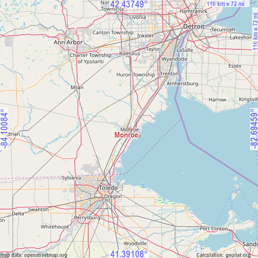
Monroe GPS coordinates[2]
41° 54' 59.148" North, 83° 23' 51.756" West
| Map corner | latitude | longitude |
|---|---|---|
| Upper-left | 42.43749°, | -84.10084° |
| Center: | 41.91643°, | -83.39771° |
| Lower-right: | 41.39108°, | -82.69459° |
| Map W x H: | 116.3×116.3 km | = 72.3×72.3mi |
| max Lat: | 71.29058° ⇑25.1% North |
| Monroe: | 41.91643° |
| min Lat: | ⇓74.9% South 19.06759° |
| min Long | Monroe | max Long |
| -171.73463° | -83.39771° | -66.98998° |
| W 60.9%⇐ | ⇒39.1% E |
Elevation
Elevation of Monroe is 181 m = 594 ft, and this is 113.8 m = 373 ft below average elevation for this country.
| Max E: |
3189 m = 10463 ft | 54.8% |
| Avg. | 294.8 m = 967 ft | |
| Monroe | 181 m = 594 ft | |
Min E: |
-60 m = -197 ft | 45.2% |
See also: United States elevation on elevation.city.
Geographical zone
Monroe is located in North temperate zone (between Tropic of Cancer and the Arctic Circle). Distance of this Northern Tropic circle is 2054.8 km =1276.8 mi to South.| Distance of | km | miles | from Monroe |
|---|---|---|---|
| North Pole | 5346.4 | 3322.1 | to North |
| Arctic Circle | 2740.5 | 1702.9 | to North |
| Tropic Cancer | 2054.8 | 1276.8 | to South |
| Equator | 4660.7 | 2896 | to South |


Nearby cities:
15 places around Monroe: (largest is in red/bold)
• Carleton
15.9 km =9.9 mi,  2°
2°
• Detroit Beach
6.1 km =3.8 mi,  74°
74°
• Dundee
22.1 km =13.7 mi,  281°
281°
• Flat Rock
21.8 km =13.5 mi,  23°
23°
• Gibraltar
26.3 km =16.3 mi,  40°
40°
• Lambertville
25.4 km =15.8 mi,  228°
228°
• Luna Pier
12.7 km =7.9 mi,  196°
196°
• Maybee
13.8 km =8.6 mi,  314°
314°
• Rockwood
21.2 km =13.2 mi, 36°
• South Monroe
2.8 km =1.7 mi,  215°
215°
• South Rockwood
19.9 km =12.4 mi,  34°
34°
• Stony Point
11.3 km =7 mi,  75°
75°
• Temperance
20.8 km =12.9 mi, 222°
• West Monroe
2.8 km =1.7 mi,  264°
264°
• Woodland Beach
7.5 km =4.7 mi, 69°
Sources, notices
• [Note1] Compared only with cities in United States existing in our database
• [Src1] Map data: © OpenStreetMap contributors (CC-BY-SA)
• [Src2] Other city data from geonames.org with taken over terms of usage.
• [Src3] Geographical zone / Annual Mean Temperature by Robert A. Rohde @ Wikipedia
